Colorado Web Cams
Crestone, Colorado
(Note: This page may need reloading on some browsers for new views)
Crestone is an isolated community located in south-central Colorado, in Saguache County, in the foothills of the Sangre de Cristo Mountains. The webcams are located south of Crestone in the Baca Grande. The Baca is a spiritual center, with several world religions represented here, including: a Hindu temple, a couple of Zen centers, several Tibetan Buddhist centers, different retreat centers, and miscellaneous New Age happenings. Crestone's elevation is 7,923 feet (2,415 meters). However, in the Baca, the elevation varies, with an average elevation of 8,100 feet (2,469 meters). As of the 2020 census, the population of Crestone was 141, but most of the locals live in the Baca, with an estimated population of 2,000 people.
Crestone is named for the 14,000-foot (1,917 meter) plus high mountains that lie just east of the town. Just to the south and next door to the Baca are the tallest sand dunes in North America, at the Great Sand Dunes National Park and Preserve. Inside this National Park, besides the beautiful tall sand dunes, on the park's north end, bordering the Baca, is the Crestone Crater, which many scientists feel was formed by a meteorite impact in 1892, but it's still being studied to determined if it is indeed one. You can click here if you would like to read a newspaper article I wrote about it in 2011.
Crestone's closest neighboring town, 12 miles (19 kilometers) away to the west, is the very small town of Moffat, with Moffat being a bedroom community to Crestone. The second closest town to Crestone is Westcliffe, just 15 miles (24 kilometers) away to the east. However, despite the two towns being located so close to each other, they sit on opposite sides of the rugged Northern Sangre de Cristo mountain range, with the four main mountains between them all having summits over 14,000 feet / 4,267 meters high. Since there are no roads crossing the mountains directly between them, driving from the Crestone area to Westcliffe requires a long detour around the northern or southern ends of the range, spanning a 105-mile drive over the Sangre de Cristo's northern end, including going over Poncha Pass, so the drive takes two hours between the two towns!
The climate in Crestone brings mild summers and cold winters. Down below Crestone is the San Luis Valley, the highest and largest alpine valley in the world, and it is also a semi-desert - and a very cold one at that - as it's the second coldest valley in the lower 48 states (the Gunnison Valley, located in the next valley over to the west, is the coldest). The coldest temperature ever in the Crestone/Baca was -26°F/-32°C set on February 1, 1985, and the warmest day was 98°F (38°C) on July 20, 2005. I should note that back on January 13, 1963, a state wide severe Arctic outbreak hit, and an unofficial temperature reading in the town of Crestone that morning was recorded at -32°F (-36°C), but Crestone had no official weather record keeper at the time. The snowiest snow season in Crestone since 1982, was in 2008-09, back when I, your webmaster, measured 99 inches (252 centimeters) of snow**. Yearly, the average snow season sees 64.0 inches (163 centimeters) fall in the Crestone-Baca (which is pretty much the average snowfall expected for Colorado).
The last cam shown on this page, which we call the Zoom Tour Cam, covers about 270 degrees of the local area, including the Crestone area mountains, the northern San Luis Valley, and the San Juan Mountains to the west. Average elevation of the mountain peaks shown are around 14,000 feet (1,917 meters). To see a list of these mountain peaks and their elevation that are seen on the cam, please go here.
**Yes, Crestone is my hometown and I have been the official COOP (Cooperative Observer) reporter in the Crestone-Baca for the National Weather Service since I moved here in 2002.
- Click on images below for a larger view -
Crestone Peaks, Crestone CO - Click
here for streaming and or
time-lapse view
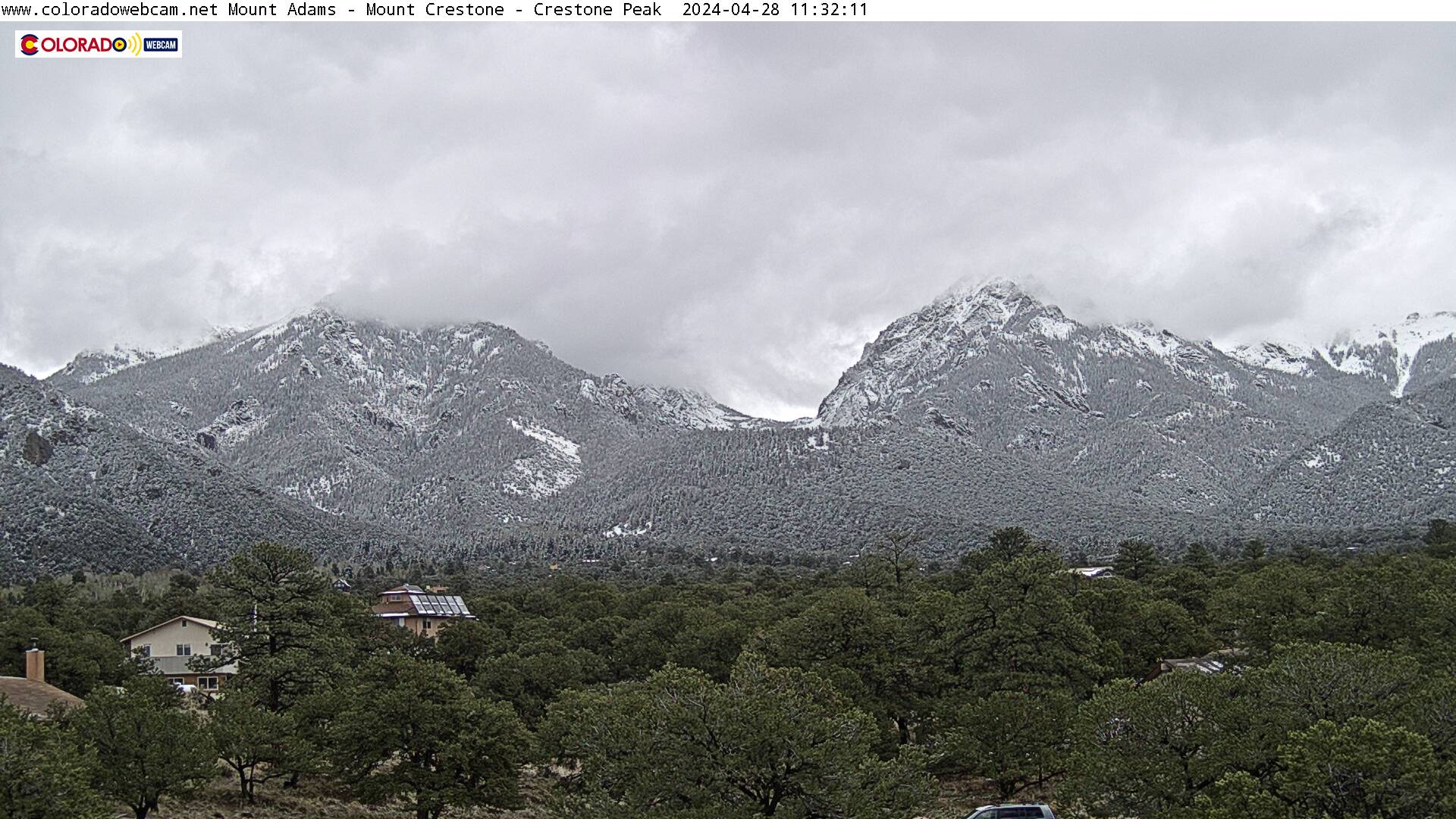
Looking east of Crestone at 13,941' Mount Adams (left)
and 14,171' Mount
Crestone (right), AKA Kit Carson Mountain, FKA Crestone Peak
(please see note on
the mountains' names at the streaming page, using its above link)

The Crestone Baca looking north
- Click
here for streaming view
On the far left is the San Juan Mountains. The
Collegiate Peaks are seen in the middle and the Sangre De Cristo Mountains are
on the right.
Blanca Peak, as seen from Crestone CO
- Click
here for streaming view
Looking south of Crestone at 14,351-foot Blanca Peak.
You can also see the free-standing volcanic San Antonio Mountain (10,908 feet) in the distance, to the far right of Blanca Peak.
Crestone Foothills, San Luis Valley, and San Juan
Mountains - Click
here for streaming view
Looking to the west. Where you see the San Juan Mountains, Wolf Creek Pass is on the left. Then near the bottom of the cam is the main road in the Baca, Camino Baca Grande.
Crestone Zoom Tour Cam
Click on Live for 270 degree Zoom Streaming Tour and to view a list of these mountain peak's names and their elevations.
Cams are located on top of the CrestoneBaca Weather Tower. These webcams come to you by Colorado Web Cams (this domain) and Coloradowebcam.net.
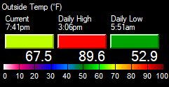
Crestone Baca Temperature:
- Crestone Map -
| Colorado Web Cams | Saguache | Villa Grove | Great Sand Dunes | Poncha Pass | Crestone Weather Center |