![]() Public Information Statement
Public Information Statement![]()
Close out and Wrap-up on the 2024 - 2025 Snow Season
(posted by Keno
on July 2 at
445 am)
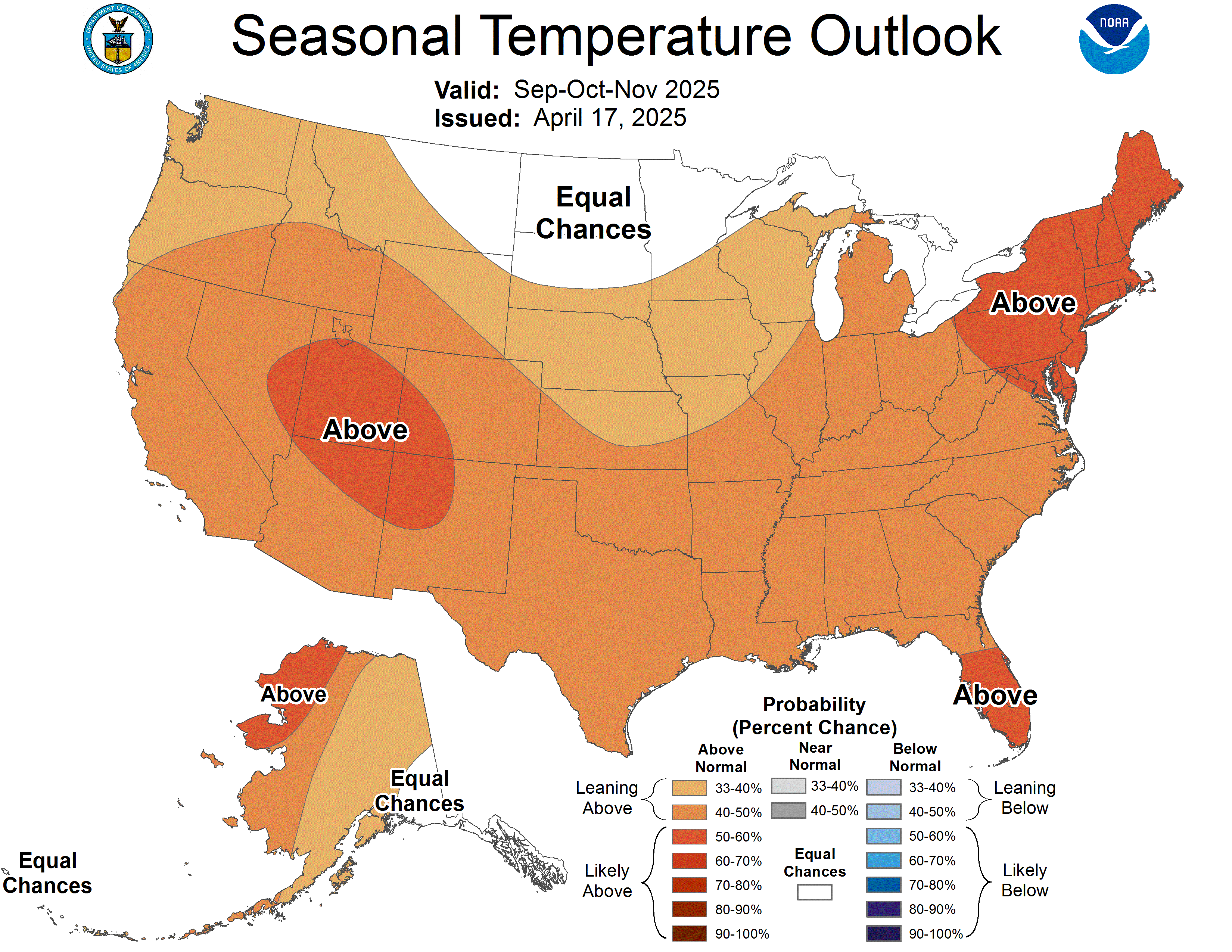
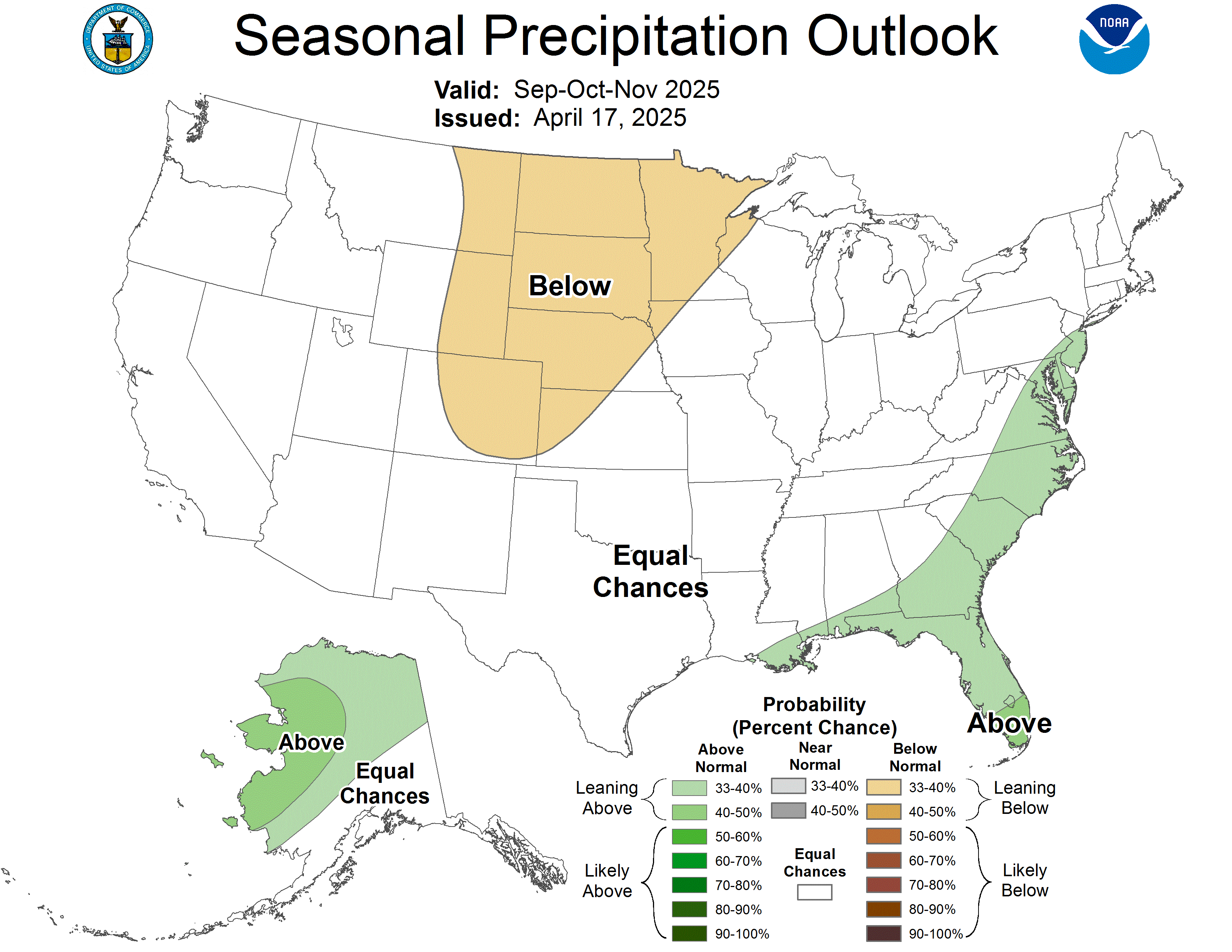
As all folks who keep weather records know, and as most Crestonians also know - since I always remind you once a year of this, June 30 marks the last day of the snow season all over the globe. Looking back on our last season, well, you guessed it if you realized that once again, we saw well below average snowfall this past and now last season. For the 2024-25 snow season, we only received 40.6 inches of snow, yes, that all folks! Our yearly average, which is 62.6 inches, has been falling steadily for the last 20 years plus now - 100% thanks to man-made climate change.
In a nutshell, the snow total we saw this past snow season, is the sixth lowest snow season ever seen in our area and now for our all time Top 10 least snowless years (or if you prefer, "snow seasons"), 9 of the 10 least snowless years for our area have taken place since 2000, including the Top 9! Only the 1995-96 snow season, sitting in 10th place, took place in the last century. During the last 12 months, only twice, in November 2024 and last January, did we see above normal snowfall for the month.
That my friends, is very sad indeed, and even more terrible than many realize, as it isn't just here in the greater Crestone area where this out of control madness is happening, but this is taking place everywhere on our planet Earth. As the great Stevie Wonder once stated, "If we don't change, the world will soon be over".
High country hikers
need to beware this holiday week!
(posted by Keno June 30 at 1050 pm)
The snow level will be at around 13,000 feet for several afternoons for the this week and the 4th of July weekend. While this isn't totally unusual for above 14,000 feet any time of the year that high up, usually below that doesn't see snow in the first 3 weeks of July. Now, as no new snow accumulation is expected from this, if you plan to head to the top of our 14ers, beware of this. Updated on July 2 at 1 am: The 1 am report on the snow above 10,800 feet, still sees the snowpack at one inch, which has been unchanged for over the last week now and is at 100% of normal for this time of year. It's normal to see this amount of snowpack up there until the first week in August, but looking up at that mountain, or at it from viewing our zoom webcam, it looks like the snow cover in the last week is less than what we normally see for around July 1 and while I hope I'm wrong, it's looking like in the next 2 weeks or so, it will be down to just a trace up there.
More important.... There's also a chance for lighting strikes each
afternoon in the high country above 10,000 feet - which means
that this
covers all
of our mountains' area (really, all our foothills, too).... So be aware if you are heading into
our high country, as
lightning strikes can and sometimes do come out of even a blue sky,
especially up high in any mountain range.
While this is a rare event that happens less than 10% of the
time, in reality, the lighting is coming from a cloud
that can't be seen, and as far away as 25 miles - and sadly, these are the strongest
known lighting strikes to take place (called "positive lightning",
click on link to learn more on this).
But believe me, you
don't want to be on the other end of such a strike!
Most don't survive a positive lighting strike.
New Precipitation Record Set on Monday in the Crestone /Baca
On Monday, June 2, we saw a record broken for daily precipitation when
I measured 0.45" for the 24 hour period. This shattered the old daily record for the date
which was 0.19, set in 2009.
N
The NWS actually came out with these new icons over a year ago, but there are just hundreds of them to download into my domain, as just about every combination of weather conditions and every percentage for precip (rounded off to the nearest 10) are included, and that was why I waited so long to use them. There were just too many different combos (or if you prefer, web files) to download. But while it only takes seconds to download any number of files these days, the problem was in trying to decide which ones to choose from and then download and even worst, try to organize them all into new files that I would have to create on the domain. So instead, what I'm doing, is just hot linking the icons from their online locations on the NWS's server, to our forecast page. While that might sound perhaps easy to a non web coder to do, well, it is, but it's very much time consuming with each and every icon used, since I can't just hot link to each image, but I need to recode them so they show up correctly for each time slot and at the correct size I need to use. In turn, this means I have to do this nine times for each icon spot per forecast.
So while this new set up is easy to do, it's very much time consuming. But I am retired from all other work now, other than working on this weather site and also the domain's cam sites, as my other web sites, which all were once proactive, aren't any longer (for the most part). I also no longer can go hiking up in the mountains as I used to do at least twice a week, or even hike around town anymore unless it's downhill. Since I also no longer drive or have a car, I have to rely on my grandsons to take me places (when they have the time). So, I'm home a lot these days and guess what that means? It means I have the time to do this extra work! So I don't really mind the extra work at all, as it's something to do.