Keno's Home and Crestone's Official Weather Station
Crestone, Colorado
Local Weather Conditions
Updated every 10 Minutes.
[Click on Refresh/Reload to Update Page]
Latitude: N 37.98 Longitude: W -105.68 Elevation: 8085 Feet
|


|
|
|
|
|
|
|
|
 |
   |
- Current Graphs - |
|


- Weather Conditions Nearby -
-
Click on
HERE for Colorado conditions elsewhere -
(See this
notice about these conditions)
![]() 30 Day
& 8 to 14 Day Outlooks
30 Day
& 8 to 14 Day Outlooks![]()
(From the NWS, updated at different times)
-
Local Forecast -
(Updated: 420 PM MDT on April
17)
![]() Red
Flag Warning in effect
Today until 9 PM MDT
for the Entire Area
Red
Flag Warning in effect
Today until 9 PM MDT
for the Entire Area![]()
![]() !Air Quality Alert
Today for entire area!
!Air Quality Alert
Today for entire area!![]()
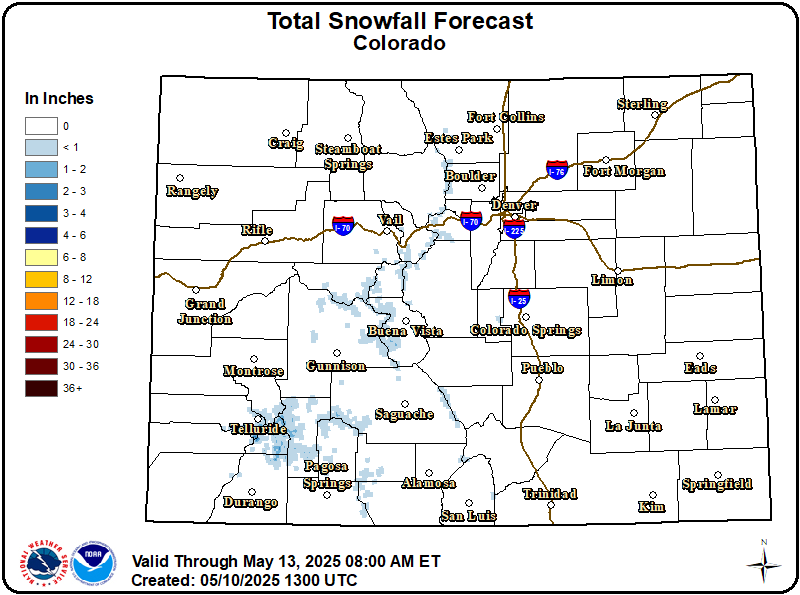
![]() Winter Storm Warning in effect From
6 AM Friday to 6 PM MDT
Saturday MDT
Winter Storm Warning in effect From
6 AM Friday to 6 PM MDT
Saturday MDT![]()
Rest of
Today
![]()
Blow'g Dust
Very Windy
High 61°F
Tonight

Cloudy/Blo'g Dust
Windy/30% Snow
Low
28°F
Friday

80% Chance Snow Blow'g Snow/Brzy
High 38°F![]()
Friday
Night

90% Ch Snow
Heavy Snow
Low 22°F
Saturday
90% Chance
Snow Likely
High 33°F![]()
Saturday
Night
30% Chance
Snow
Low 18°F
Sunday

Partly
Sunny
High
48°F
Sunday
Night
![]()
Mostly
Clear
Low
22°F
Monday

Mostly
Sunny
High
57°F
|
Weather Info
Forecast below is for the entire area, forecast
above is for around 8,000 feet only.... The normal high
temperature today around the Crestone/Baca area is 57°, record
high is 72°,
the normal low is 28°, record low is 10°....
Note:
When percentages for precip are less than 30%, they aren't shown
in the icons above.
Click
here for the latest
Colorado Forecast Maps, and more.
Today
Hazy sunshine.. with widespread blowing dust/sand.... Seasonal highs below 10,000 feet of
50° to 64° and
with highs above 10,000 feet of 32° to 44°... Very windy, with a west southwest wind around 40 mph, with gusts as high as
50 to 60 mph possible in the valley and foothills and with 65 mph gusts in the
mountains.
Tonight
Partly cloudy
early... with areas of blowing dust/sand, mainly before 9pm.... then
becoming cloudy after midnight with a
slight chance for snow after 5 am in the valley ... and with a
30 to 40% chance for
snow after 5 am in the foothills and mountains... Seasonal lows below 10,000 feet of
| |||||||||||||||||||||||||