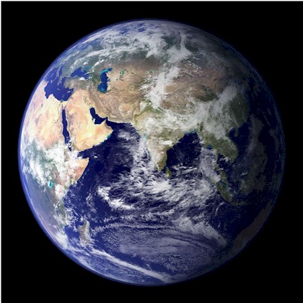
Europe is a small continent located in the Northern Hemisphere and in the Eastern Hemisphere. It is bordered by the Arctic Ocean to the north, the Atlantic Ocean to the west, the Mediterranean Sea to the south, and Asia to the east. Europe shares the landmass of Eurasia with Asia, and of Afro-Eurasia with both Asia and Africa.
Europe covers about 10.18 million km2 (3.93 million sq.
mi), or 2% of Earth's surface (6.8% of land area), making it the second-smallest
continent. Politically, Europe is divided into about fifty sovereign states, of
which Russia is the largest and most populous, spanning 39% of the continent and
comprising 15% of its population. Europe had a total population of about 745
million (about 10% of the world population) in 2021; the third-largest after
Asia and Africa. The three largest urban areas of Europe are Moscow, London and Paris. All have over 10 million residents, and as such have been described as megacities. While Istanbul has the highest total city population, it lies partly in Asia. 64.9% of the residents live on the European side and 35.1% on the Asian side. The next largest cities in order of population are Madrid, Saint Petersburg, Milan, Barcelona, Berlin, and Rome, each having over three million residents.
The definition of Europe as a geographical term has been in use since the mid-19th century. Europe is taken to be bounded by large bodies of water to the north, west and south.
It's limits to the east and north-east are usually taken to be the Ural Mountains, the Ural River, and the Caspian Sea.
To the south-east, the Caucasus Mountains, the Black Sea, and the waterways connecting the Black Sea to the Mediterranean Sea.
Islands are generally grouped with the nearest continental landmass, hence Iceland is considered to be part of Europe, while the nearby island of Greenland is usually assigned to North America, although politically belonging to Denmark. Nevertheless, there are some exceptions based on sociopolitical and cultural differences. Cyprus is closest to Asia Minor, but is considered part of Europe politically. Malta was considered an island of North-western Africa for centuries, but now it is considered to be part of Europe as well.
The European climate is affected by warm Atlantic
currents, such as the Gulf Stream, which produces a temperate climate for much of
the continent. Further from the sea, seasonal differences are more noticeable
producing more continental climates. Europe sees a prevailing wind direction from the west. The climate is milder in comparison to other areas of the same latitude around the globe due to the influence of the Gulf
Stream. The Gulf Stream is nicknamed "Europe's central heating", because it makes Europe's climate warmer and wetter than it would otherwise be. The Gulf Stream not only carries warm water to Europe's coast but also warms up the prevailing westerly winds that blow across the continent from the Atlantic Ocean.
Therefore, the average temperature throughout the year of Aveiro, Portugal, is 16°C (61°F), while it is only 13°C (55°F) in New York City, which is almost on the same latitude
and borders the same ocean. Berlin, Germany; Calgary, Canada; and Irkutsk, in south-eastern Russia,
also lie on and around the same latitude. January temperatures in Berlin average around 8°C (14°F) higher than those in Calgary and they are almost 22°C (40°F) higher than average temperatures in Irkutsk.
There are officially 50 countries going by internationally
recognized sovereign countries in Europe, but that's leaving out several others, like
the three countries of the United Kingdom along with at least 10 other countries.
Iceland (Icelandic: Ísland, pronounced [ˈistlant]) is a Nordic island country between the North Atlantic and Arctic Oceans,
it's landmass is mainly on the Eurasian Plate, making it a part of Europe, between North America and Europe. It is linked culturally with Europe and is
Europe's most sparsely populated country. Its capital and largest city is Reykjavík, which is home to about 36% of the country's roughly 380,000 residents. The official language of the country is Icelandic.
Iceland is the world's 18th-largest island, and Europe's second-largest island after Great Britain and before Ireland.
The main island covers 101,826 km2 (39,315 sq mi), but the entire country is
103,000 km2 (40,000 sq mi) in size, of which 62.7% is tundra. Iceland is closer
to continental Europe than to mainland North America, although it is closest to
Greenland (290 kilometres; 155 nautical miles), an island of North America.
Iceland is generally included in Europe for geographical, historical, political,
cultural, linguistic and practical reasons. Geologically, the island includes
parts of both continental plates.
The climate of Iceland's coast is subarctic. The warm North Atlantic Current ensures generally higher annual temperatures than in most places of similar latitude in the world.
The highest air temperature recorded was 30.5°C (86.9°F) on 22 June 1939 on the southeastern coast. The lowest was −38°C (−36.4°F) on 22 January 1918
in the northeastern hinterland. Snowfall in winter is more common in the north than in the south. 750 square kilometers of Iceland’s glacier ice has melted since the year 2000. Iceland’s annual CO2 emissions and per capita CO2 emissions rose from 1950 to 2018, but both metrics have been on the decline since 2018. A majority of Iceland’s CO2 emissions come from oil.
In an effort to combat the effects climate change has on Iceland’s glaciers, Iceland has worked to make its electricity completely sustainable. As of 2015, nearly all of its electricity comes from renewable energy. Thirteen percent of the country’s electricity comes from geothermal energy—which also heats ninety percent of Iceland’s homes—and the rest comes from hydropower.
The above livestream comes from the current volcano eruption going on in Iceland.
Dalvík is a village within the municipality of Dalvíkurbyggð in North Iceland, with a population of approximately 1,400 people.
Dalvík is placed in the natural paradise that is Tröllaskagi peninsula and has great access to the ocean.
The town's name means "valley bay". The local economy is based upon fisheries and fish processing,
and it's also a tourist destination for boat trips in whale watching and heli skiing.
Dalvík, features a subarctic maritime climate. It experiences short, cool, and cloudy summers, alongside long, freezing, snowy, and overcast winters. Temperatures typically range from 25°F to 56°F
(-4°C to 13°C year-round and rarely drop below 14°F (-10°C) or rise above 64°F
(18°C).
The town experiences the "Midnight Sun" in the summer months (June – August), characterized by near-constant daylight.
In winter, daily highs around 34°F (1°C) and lows averaging 25°F (-4°C). Daylight is highly limited, and heavy snowfalls and overcast skies are common.
Precipitation is frequent but generally light, with a steady chance of rain, drizzle, or snow throughout the year.
For snow: The highest average snowfall typically occurs in January, bringing about 50 centimeters (19.7 inches) of snow.
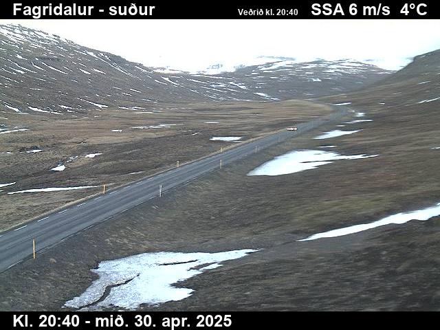
Fagridalur (valley elevation 350 meters / 1148 feet), which translates from Icelandic to "Beautiful Valley",
is a scenic mountain valley and pass in East Iceland. Situated along Route 92, which serves as the primary road link connecting the inland hub of Egilsstaðir to the seaside fjord town of Reyðarfjörður.
Travelers passing through enjoy a scenic drive through typical East Iceland mountain terrain, with green hillsides, dramatic peaks, and ever-changing light conditions that make this stretch particularly photogenic.
Fagridalur, experiences a subarctic maritime climate. It is characterized by cool summers, relatively mild winters for its latitude, and highly unpredictable, windy weather.
Summers are cool and pleasant, with average highs generally ranging between 10°C and 14°C (50°F
to 57°F). Daylight stretches up to 21 hours around the summer solstice.
Winters are mild (for Iceland) but volatile. Average winter temperatures hover around 0°C (32°F), though the valley can experience drops to between -5°C and -10°C (14°F
and 23°F) during cold spells. The snow is heavy here. Monthly snowfall
totals can exceed 50 centimeters (20 inches) during the peak winter months
(December thru February).
- Norway -
Norway is a Scandinavian country encompassing mountains, glaciers and deep coastal fjords.
Norway has a total area of 385,207 square kilometers (148,729 sq. mi) and had a population of 5,488,984 in January 2023.
The country shares a long eastern border with Sweden. It is bordered by Finland and Russia to the northeast and the Skagerrak strait to the south. Norway has an extensive coastline facing the North Atlantic Ocean and the Barents Sea.
Norway's climate is mostly temperate, with mild winters and cool summers in most areas. However, temperatures and precipitation varies by region and season.
Skarsvag is the northern most fishing village in the World,
located in Nordkapp Municipality in Finnmark county, Norway. The local fishing fleet primarily fishes for cod in the
waters. There are about 60 residents in Skarsvåg. The village is also the northernmost settlement in the world that is accessible via a major road network, the European route E69.
Located well north of the Arctic Circle, the sun never rises (polar night) from November 20th to January 22nd, while you can watch the midnight sun from May 13th to July 31st, and the white nights, in which it is not completely dark even at midnight, from April 8th and, after the midnight sun, again until September 4th.
The climate of the North Cape is subarctic, with very cold winters and very cool to quite cold summers.
Yet given the position exposed to ocean currents including the Gulf Stream, in winter, the temperature only drops to around -15°C (5°F) on the coldest days, while in southern Finnmark it can drop to -40°C (-40°F) or below. The coldest record
ever here is -18.6°C (-1.5°F) set in January 1986. On the other hand, even in the height of summer,
it stays on the cold side, with normal highs around 7 to 8°C (44 to 46°F), in addition, the wind chill increase the feeling of
the cold. In May (and October) it's normally cold, and
it can snow. The highest temperature record is 28.6°C (83.5°F), set in July 1960. At
the North Cape, precipitation amounts to about 865 mm (34 in) per year.
Geiranger is a small tourist village in Sunnmøre region
of Møre og Romsdal county in the western part of Norway. The village is
surrounded by majestic mountain peaks, 800 meter/2,625 foot high cliffs, cascading
waterfalls and the Geirangerfjord (English: Geiranger Fjord) – the crown jewel of the Norwegian
fjords, an impressive 15 kilometers/9 miles long and
260 meters/853 feet deep. The small village of Geiranger is located at the end of the fjord, where the Geirangelva river empties into it. While it's very
beautiful and one of Norway's most visited tourist site, the Geiranger Fjord is under constant threat from the mountain Åkerneset, which is about to erode into the fjord. A collapse would produce a tsunami, hitting several nearby towns including Geiranger in a
few short minutes.
Climate: In summer, July and August see average highs
around 11°C (51.8°F). In wither, its lowest temps are in January and February, with averages dipping down to -6°C (21.2°F) and -5°C (23°F) respectively.
Because weather record keeping in this part of the world is flat out terrible and
mostly unknown for so many areas, Geirangerfjord/Geiranger records are difficult to pinpoint,
but Norway's official weather stations show the recorded highest ever
temperature of 35.6°C (96.1°F),
but with no date given when this occurred, and some reports claim that this
reading may have been given in error. For the coldest temp ever recorded in
winter here, I can't find anything official on this anywhere! Most visitors to
tourist towns do like to know this kind of weather info in advance before a
visit. Heck, it
was from emails that made me realize, that all of our different cam sites'
readers what to know this for all of the locations I cover on my different cam pages
worldwide. But I can't give out info that isn't available! Yet I'll keep trying
from time to time for
Geiranger's future visitors, as sooner or later, something might show up.
- Denmark -
Denmark is a Scandinavian country comprising the Jutland Peninsula and numerous islands. It's linked to nearby Sweden via the Öresund bridge.
Denmark has a temperate climate, characterized by cool to cold winters, with mean temperatures in January of 1.5°C (34.7°F), and mild summers, with a mean temperature in August of 17.2°C (63.0°F). The most extreme temperatures recorded in Denmark, since 1874 when recordings began, was 36.4°C (97.5°F) in 1975 and −31.2°C (−24.2°F) in 1982.
Because of Denmark's northern location, there are large seasonal variations in daylight: short days during the winter with sunrise coming around 8:45 am and sunset 3:45 pm (standard time), as well as long summer days with sunrise at 4:30 am and sunset at 10 pm
Wildlife seen on a small piece of land in the northern region of Denmark.
Right next to the stream you see, and underneath the old tree also seen, is a
favorite place for badgers, foxes, martens, and many other animals and birds.
- Sweden -
Sweden, is a Nordic country located on the Scandinavian Peninsula in Northern Europe.
Sweden has thousands of coastal islands and inland lakes, along with vast boreal forests and glaciated mountains. Its principal cities, eastern capital Stockholm
(its largest city) and southwestern Gothenburg and Malmö, are all coastal. Stockholm is built on 14 islands.
It borders Norway to the west and north, and Finland to the east. At 450,295 square kilometres (173,860 sq mi),
Sweden is the largest Nordic country by both area and population, and is the
fifth-largest country in Europe. Sweden has a population of 10.6 million, and a low population density of 25.5 inhabitants per square kilometre (66/sq mi); 88% of Swedes reside in urban areas.
The country's land has been inhabited since prehistoric times, around 12,000 BC.
Because of Sweden's high latitude, the length of daylight varies greatly. North of the Arctic Circle, the sun never sets for part of each summer, and it never rises for part of each winter. Most of Sweden has a temperate climate, despite its
northern latitude, with largely four distinct seasons and mild temperatures
throughout the year. The northern parts of the country have a subarctic
climate while the central parts have a humid continental climate. The
coastal south can be defined as having either a humid continental climate, or an oceanic climate
depending on which isotherms maps are used. The highest temperature ever recorded in Sweden was 38°C (100°F) in Målilla in 1947, while the coldest temperature ever recorded was −52.6°C (−62.7°F) in Vuoggatjalme
on 2 February 1966. On average, most of Sweden receives between 500 and 800 mm (20 and 31 in) of precipitation each year, making it considerably drier than the global average. The south-western part of the country receives more precipitation, between 1,000 and 1,200 mm (39 and 47 in), and some mountain areas in the north are estimated to receive up to 2,000 mm (79 in). Despite northerly locations, southern and central Sweden may
see almost no snow in some winters. The snowiest winter ever in Sweden was
in the snow season of 1965/66, with an average snow depth of 86 centimeters
(34 inches) across 43 weather stations; with the all time record for snow depth
being 327 cm (or 129 in) in Kopparasen in February 1926.
Liseberg Amusement Park, Gothenburg, Sweden (From MED -
Mediateknik)
Live webcam from Liseberg
Amusement Park, located in Gothenburg, Sweden.
Liseberg started as a public garden way back in 1923 but soon evolved into an amusement park with various rides and attractions.
The park offers a wide range of attractions for visitors of all ages, including roller coasters, thrill rides and family-friendly attractions like carousels and play areas.
Gothenburg is the second-largest city in Sweden,
situated off the Gota alv River on the country's west coast. An important
seaport, it's known for its Dutch-style canals and leafy boulevards like the
Avenyn, the city's main thoroughfare, lined with many cafes and shops. The
city's elevation's is 12 m (39 ft.), covering an area of 447.76 km2 (172.88
sq. mi), and its population in 2024 was 608,462 (city) and at 1,080,980 for
its metro area. Gothenburg has an oceanic climate thanks to its influence of
the Gulf Stream. Summers are warm and pleasant, but the area does see some
rainy days; Winters are cold and windy, with snow mainly occurring from December to March.
Lofsdalen is a quiet, family friendly mountain village close to Stockholm/Arlanda, known for year-round outdoor activities from skiing
from December–April to hiking and fishing in summer.
The ski area here has 9 lifts and 25 slopes and offerings alpine skiing,
cross-country skiing trails and downhill runs.
In the Lofsdalen village there are a total of 170
residents. Whereas in the whole Lofsdalen area there are 262 inhabitants.
The village's base elevation is 672 meters (2,005 feet) above sea level,
with the general altitude for the mountain summit at 1,125 meters (3,691 feet).
The area has untouched nature and is rich in wildlife. Reindeer, moose, and foxes are seen daily, and from April to September many visitors also catch a glimpse of the Swedish brown bear.
Lofsdalen has a subarctic/continental climate with significant temperature swings. Winters are long, cold, and snowy, while summers are short, mild, and vibrant, perfect for hiking and mountain biking.
June to August sees pleasant daytime highs reaching an average of 17°C to 19°C
(64°F), with cool nights averaging around 8°C (46°F). In winter, freezing temperatures average from -7°C to -3°C
(19°F to 27°F) during the day and can drop to -13°C (8°F) or lower at night.
Snowfall averages about 240 centimeters (95 inches) annually.
Finland is a Northern European nation. Its capital, Helsinki, occupies a peninsula and surrounding
islands in the Baltic Sea. Finland is one of the world's northernmost countries.
Because of its location, its land
cover is predominantly boreal forest biome, with more than 180,000
recorded lakes. It borders Sweden to the northwest, Norway to the north,
and Russia to the east, with the Gulf of Bothnia to the west and the
Gulf of Finland to the south, opposite Estonia. Its total
area is 338,455 km2 (130,678 sq. mi).
Finland 's population as of 2025 census was 5,652,881. The official
languages are Finnish and Swedish, the mother tongues of 83.5 percent
and 5.0 percent of the population, respectively.
A quarter of Finland's territory lies within the Arctic Circle and the midnight sun can be experienced for more days the farther north one travels. At Finland's northernmost point, the sun does not set for 73 consecutive days during summer and does not rise at all for 51 days during
winter. In the Köppen climate classification, the largest part of Finland lies in the boreal zone, characterized by warm summers and freezing winters.
Finland is near enough to the Atlantic Ocean to be continuously warmed by the Gulf Stream. The Gulf Stream combines with the moderating effects of the Baltic Sea and numerous inland lakes to explain the unusually warm climate compared with other regions that share the same latitude, such as Alaska, Siberia, and southern Greenland.
Finland's annual snowfall varies significantly by region, ranging from about
50 to 70 centimeters (20 to 28 inches ) of total accumulation in the south to 175
to 225 centimeters (69 to 89 inches) in northern Lapland. Snow seasons are longest in the north, lasting 6 to 7 months, while the southern coast usually sees persistent snow cover for only 3 to 4 months.
Levi Ski Resort, Gondoli ala-asema/Lower station, Finland
Levi Ski Resort is located in the western Lapland, in
the middle of nature and large wilderness areas. The peak elevation is 531
meters (1,742 ft.). There are 43 ski slopes (17 of which are floodlit) and 27 ski
lifts in Levi. Ascending the mountain are 2 gondolas, 1 chairlift, 14 T-bar
lifts, 5 stick lifts, 4 rope tows, and 1 magic carpet for children. Levi is one
of two locations of gondola lifts in Finland. The skiing and snowboarding season
in Levi is fairly long, often lasting from October to mid-May. Levi Ski Resort typically sees an average annual snowfall of around 120 centimeters (47 inches).
Helsinki, Finland’s southern capital, sits on a peninsula in the Gulf of Finland.
It's the most populous city in Finland with about 675,000 people living in the
municipality, 1.25 million in the capital region and 1.58 million in the
metropolitan area. This cam shows different views of the
Helsinki.
The majority of Helsinki-dwellers speak English in addition to their mother tongue of Finnish or Swedish. Helsinki is 80
kilometers (50 mi) north of Tallinn, Estonia, 360 kilometers (220 miles) north of Riga, Latvia, 400
kilometers (250 miles) east of Stockholm, Sweden, and 300 kilometers (190 miles) west of Saint Petersburg, Russia.
Helsinki has a humid continental climate. Due to the moderating influence of the Baltic Sea and the North Atlantic Current, winter temperatures are higher than the northern location would suggest, with an average of −4°C (25°F) in January and February. The average maximum temperature from June to August is around 19 to 22°C (66 to 72°F).
- Estonia -
Estonia is a country in Northern Europe, bordering the Baltic Sea and Gulf of Finland.
With more than 1,500 islands, its diverse terrain spans rocky beaches, old-growth forest and many lakes. Formerly
a part of the Soviet Union, it's dotted with castles and hilltop fortresses. The capital, Tallinn, is known for its preserved Old Town, museums and the 314m-high Tallinn TV Tower, which has an observation deck.
The oldest known settlement in Estonia is the Pulli settlement that dates to the early 9th millennium BC, making it at least 11,000 years old. Neolithic ceramics of the Narva culture appeared in around 5300 BC.
Today, Estonia is known as being among the least corrupt countries in the world and ranks high in international rankings for education, human development, press freedom, online public services, and the prevalence of technology companies.
Estonia has a transitional climate that lies between continental and maritime influences.
It is notably milder than that of other regions at the same latitude due to the moderating effects of the North Atlantic Current.
The highest recorded temperature is 35.6°C (96.1°F) set in 1992, although the unofficial record high temperature is 38.0°C (104.8°F) from the same year,
while the lowest reading is -43.5°C (−46.3°F) set in 1940. The annual average precipitation is 662
millimeters (26.1 inches)
yet the country sees little snowfall, about 20 to 30 centimeters (8 to 12 inches) of snowfall annually, though this varies significantly depending on the region. Snow generally lasts from December through March.
Tallinn, Estonia’s capital on the Baltic Sea, is the country’s cultural hub. It retains its walled, cobblestoned Old Town, home to cafes and shops, as well as Kiek in de Kök, a 15th-century defensive tower. Its Gothic Town Hall, built in the 13th century and with a 64m-high tower, sits in historic Tallinn’s main square. St. Nicholas Church is a 13th-century landmark exhibiting ecclesiastical art.
Its population
was 452,564 as of 2026. It's located 80 kilometers (50 miles) south of Helsinki, Finland. It is also 320
kilometers (200 miles) west of Saint Petersburg, Russia, 300 kilometers (190 miles) north of Riga, Latvia, and 380
kilometers (240 miles) east of Stockholm, Sweden.
The
city has little sunlight in the winter, as days are usually cloudy, and it
sees only 20.7 hours of sunshine in the month in December to
58.8 hours in February. At the winter solstice, daylight lasts for less than 6 hours and 5 minutes.
Tallinn typically sees light snowfalls with light snowpack depths frequently ranging from 5
to 15 centimeters (2 to 6 inches).
While the city may not see heavy snows, it still sees averages of about 55
to 80 days of snow per year. Tallinn experiences mild summers with typical daytime highs of 15-22°C (59-72°F) and cooler evenings
of 10-15°C (50-59°F).
- Netherlands -
The Netherlands, informally Holland (Dutch is
used as the adjective for the Netherlands, as well as the demonym.), is a
country in northwestern Europe and is known for a flat landscape of canals,
tulip fields, windmills and cycling routes. In some languages, Holland is used
as the formal name for the Netherlands. However, Holland is a region within the
Netherlands that consists of the two provinces of North and South Holland. The European Netherlands has a total area of 41,543 km2 (16,040
sq. mi), including water bodies, and a land area of 33,481 km2 (12,927 sq. mi). 26%
of the land is situated below sea level. This does not cover any of the
Caribbean Netherlands. In the Lesser Antilles islands of the Caribbean, the territories of Curaçao, Aruba and Sint Maarten have a constituent country status within the wider Kingdom of the Netherlands. Another three territories which make up the Caribbean Netherlands are designated as special municipalities.
With a population of over 17.9 million people, all
living within a total area of 41,850 km2 (16,160 sq. mi)—of which the land area
is 33,500 km2 (12,900 sq. mi)—the Netherlands is the 33rd most densely populated
country, with a density of 535 people per square kilometer (1,390 people/sq. mi). The official language of the Netherlands is Dutch, which is spoken by the vast majority of inhabitants.
The Netherlands has a temperate oceanic climate with mild temperatures and precipitation throughout the year. The average winter temperature is around 3°C
(37°F), and the average summer temperature is around 17°C (63°F), though coastal regions may have more sunshine and a smaller temperature range. The climate is influenced by the North Sea and the Atlantic Ocean, and the sea also moderates the climate with onshore winds and the Gulf Stream.
Amsterdam Centraal is the Dutch capital's main public transportation hub,
located right in the heart of Amsterdam, used by 192,000 passengers a day,
making it the second busiest railway station in the country. Amsterdam Centraal was designed by Dutch architect Pierre Cuypers and opened in 1889. It features a Gothic, Renaissance Revival station building and a cast iron platform roof spanning approximately 40
meters (44
yards).
Rotterdam (/ˈrɒtərdæm/ ROT-ər-dam, UK also
/ˌrɒtərˈdæm/ ROT-ər-DAM, Dutch: [ˌrɔtərˈdɑm]; lit. "The Dam on the River Rotte") is the second-largest city in the Netherlands after the national capital of Amsterdam. It is in the province of South Holland, part of the North Sea mouth of the Rhine–Meuse–Scheldt delta, via the "New Meuse" inland shipping channel, dug to connect to the Meuse at first and now to the Rhine.
The Erasmusbrug
(English: Erasmus Bridge) is a 802-meter-long (2,631 ft.) bridge that across the New Meuse
in the center of Rotterdam, connecting the north and south parts of this city,
second largest in the Netherlands. A combined cable-stayed and bascule bridge, construction began in 1986 and was completed in 1996. It crosses the Nieuwe Maas.
Hoek van Holland Boulevard,
Netherlands (from
Strandweer.nu)
This cam is from Beachclub One on the seaside (Zeekant), takes you to the town of Hook of Holland which is situated at the mouth of the New Waterway shipping canal
that runs into the North Sea. Hook of Holland (Dutch: Hoek van Holland, pronounced [ˈɦuk fɑn ˈɦɔlɑnt]) is a coastal village in the southwestern corner of Holland, hence the name; hoek means "corner" and was in use before the word kaap – "cape".
Hoek van Holland has a mild, windy oceanic climate
characterized by cool summers, mild winters, and consistent year-round
precipitation. It's highest ever temperature reached was 38.9°C (102.0°F),
and its coldest reading being −13.0°C (8.6°F). Average yearly precipitation
is 871.8 millimeter (34.32 inches). The town sees very little snowfall and measurable snow is a rare event here.
When it does snow, it melts fast. Its last "big" snowstorm was in February
of 2021, with reports of 5 to 30 centimeters (2 to 12 inches) of snow accumulation
around the town.
The Ferry Terminal in Nes, Ameland is the central
hub for arrivals and departures on the island. Operated by Wagenborg
Passagiersdiensten, it connects Ameland to the mainland port of Holwerd via
a 45-minute regular ferry crossing.
Ameland (elevation at just 4 meters / 13 feet) is a municipality and one of the West Frisian Islands off the north coast of the Netherlands. It consists mostly of sand dunes and is the third major island of the West Frisians. It
neighbors islands Terschelling to the west and Schiermonnikoog to the east.
It's population as of January 2021 was
3,746.
Texel is one of the Dutch Wadden Islands, off the coast of the Netherlands. It’s known for the bird-rich Dunes of Texel National Park, with its sandy beaches, grass-topped dunes and forest trails. In the park, Ecomare is a nature museum, aquarium and wildlife sanctuary for seals and birds. On the island's northern tip, the 19th-century Texel Lighthouse offers panoramic views of the North Sea and Wadden Sea.
Its population is 13,846. The municipality lies north of the mainland of the province of North Holland and west of the mainland of the province of Friesland.
The island of Texel was originally made up of two islands, Texel proper to the south and Eierland to the northeast, which were connected by shoals. In the early seventeenth century, the islands were connected by a dyke to keep the North Sea from ravaging the coastal areas of Texel proper. In the mid-nineteenth century a polder completed the northern half of the island. Today, Texel forms the largest natural barrier between the North Sea and the Wadden Sea.
Texel has an oceanic climate that is heavily
influenced by its offshore position. The annual average high is between 5°C
(41°F) and 21°C (70°F). While winters are similar to mainland areas, summers
remain cooler. The relative proximity to the mainland still renders heat
bursts to reach Texel with five months having recorded temperatures above
30°C (86°F). Record high is 34.6°C (94.3°F), while the lowest reading was
−19°C (−2°F).
- England -
England is a country that is part of the United
Kingdom. It is located on the island of Great Britain, of which it covers
approximately 62%. It has land borders with Scotland to the north and Wales to
the west, and is otherwise surrounded by the North Sea to the east, the English
Channel to the south, the Celtic Sea to the south-west, and the Irish Sea to the
west. Continental Europe lies to the south-east, and Ireland to the west. At the
2021 census, the population was 56,490,048. London is both the largest city and
the capital of England.
England is the origin of the English language.
The Industrial Revolution began in 18th-century England, transforming its society into the world's first
industrialized nation. England has a temperate maritime climate: it is mild with temperatures not much lower than 0°C (32°F) in winter and not much higher than 32°C (90°F) in summer. The weather is
often damp, but changeable. The coldest months are January and February, while July is normally the warmest month.
Since weather records began, the highest temperature recorded was 40.3°C (104.5°F) on 19 July 2022 at Coningsby, Lincolnshire, while the lowest was −26.1°C (−15.0°F)
on 10 January 1982 in Edgmond, Shropshire.
Oxford (/ˈɒksfərd/) is a city and non-metropolitan district in Oxfordshire, England.
The city is located at the confluence of the rivers Thames (locally known as
the Isis) and Cherwell. It had a population of 163,257 in 2022. It is 90 km (56
miles) north-west of London, 103 km (64 miles) south-east of Birmingham and
98 km (61 miles) north-east of Bristol.
Broad Street is a wide street in central Oxford, England, just north of the former city wall. The street is known for its bookshops.
View of north-west London. The foreground is the College Oak area next to Kensal Green in noth-west London. The horizon shows Wembley with Wembley Stadium to the right of the picture.
London sits on the River Thames in southeast
England, at the head of a 80 km (50-mile) tidal estuary down to the North Sea, and has been a major settlement for nearly 2,000 years.
Greater London encompasses a total area of 1,583 km2 (611 sq. miles).
London is the capital city of the United Kingdom. It is the U.K.'s
and England's largest metropolis and its economic, transportation, and cultural
center. Its population in 2023 for Greater London, of just under 10 million, made it Europe's third-most populous city, accounting for 13.4% of the UK's population and over 16% of England's population. The Greater London Built-up Area is the fourth-most populous in Europe,
and all of this makes London a megacity. Its wider metropolitan area is the largest in Western Europe, with a population of 14.9 million.
It's diverse cultures encompass over 300 languages.
London has a temperate oceanic climate. Rainfall records have been kept in the city since at least 1697, when records began at Kew. At Kew, the most rainfall in one month is
189 mm (7.4 inches) in November 1755 and the least is 0 mm (0 inches)in both December 1788 and July 1800. The wettest year on record is 1903, with a total
rainfall of 969 mm (38.1 inches) and the driest is 1921, with a total rainfall of
308 mm (12.1 inches).
The average annual precipitation amounts to about 600 mm
(23.6 in), which is half the annual rainfall of New York City. Yet
despite relatively low annual precipitation, London receives 109.6 measuable
rainy days annually. Snow is a rarity here, but snow usually falls at least once each winter.
There are no official snow records kept in London, but the most snow in
one storm is believed to have hit in February 1991 when Central London
saw a whopping (for London) 20.3 cm (8.0 inches) of snow! St James' Park recorded 20 cm
(7.9 in) on the same day.
Temperature extremes in London range from 40.2°C (104.4°F) at Heathrow on 19 July 2022, down to −17.4°C (0.7°F) at Northolt on 13 December 1981.
Bridport Harbour, East Beach, Dorset, England (From
Dorset Council UK)
Bridport Harbour, aka West Bay, is a small harbour town and resort on the English Channel coast in Dorset, England, sited at the mouth of the River Brit approximately
2.4 km |1.5 miles south of Bridport, 24.14 km |15 miles west of Dorchester at the western end of Chesil Beach.
It serves as a fishing hub and offers opportunities for pleasure boating. It generally experiences a mild, maritime climate
and the area often enjoys its own mini-climate, sometimes with more sunshine and fewer clouds than other parts of the region. The warmest month of the year is July, with an average temperature of 17.0°C | 62.6°F. On average, the month of February is considered to be the coldest time of year, with temperatures averaging at around 5.6°C | 42.0°F.
The month with the highest amount of rainfall is November (12.1 days), whereas
the one with the lowest precipitation level is September (9.4 days).
Lyme Regis Harbour, Lyme Regis, Dorset, England (From
Dorset Council UK)
This live feed shows the Lyme Regis Harbour, known to locals as “The Cobb”. This harbour, located in Lyme Regis, a coastal town in Dorset,
it dates back to the 13th century. Lyme Regis is 40 km (25 miles) west of
Dorchester and east of Exeter, and it lies by the English Channel at the Dorset–Devon border. It has noted fossils in cliffs and beaches on the Jurassic Coast, a World Heritage Site and heritage coast.
The population was estimated to be at 4,805 in 2019.
Cam offers sweeping views of the River Dart, passing boats, and the vibrant heart of Dartmouth.
The town is set on the western bank of the estuary of the River Dart, which is a long narrow tidal ria that runs inland as far as Totnes.
It lies within the south Devon area and South Hams district, and had a population of 5,064 at the 2011 census.
As with the rest of the British Isles and South West England, the area experiences a maritime climate with warm summers and mild winters
- this is particularly pronounced due to it being near the coast. Extremes range from a record low of −8.0°C (17.6°F) in January 1987, up to a record high of 30.5°C (86.9°F) during June
of 1976. It sees an average precipitation per year of 1,074 mm
(42.28 in).
- France -
France is a country located in Western Europe. It also includes overseas regions and territories in the Americas and the Atlantic, Pacific, and Indian Oceans, giving it one of the largest
discontinuous exclusive economic zones in the world. European France, shares borders with Belgium and Luxembourg to the north, Germany to the northeast, Switzerland to the east, Italy and Monaco to the southeast, Andorra and Spain to the south, and a maritime border with the United Kingdom to the northwest, and has a combined area of 643,801 km2 (248,573
sq. mi) and
a total population of 68.4 million as of January 2024.
France's climate varies by region due to its latitude,
altitude, and proximity to the sea and mountains. The country has three main
climate zones: oceanic, continental, and Mediterranean. Summers are warm, with
some thunderstorms, and winters are cold. Temperatures will drop below -0°C/32°F
in some places; and in the mountains it frequently snows. In the South, the
climate is Mediterranean. Summers are hot and winters mild and dry. The hottest
day in French history, happened in June of 2019, when the mercury shot up to
45.9°C (114.6°F) at Gallargues-le-Montueux in southern France. The nation’s
coldest temperature was recorded on 17 January, 1985, with a reading of -41°C
(-41°F) at Mouthe (Doubs), a village on the Swiss border.
Paris, France's capital, is the largest city in France, situated in the north-central part of the country.
Nicknamed The City of Light, its area covers 105 km2 (41 sq. mi) and it's average
elevation is 28–131 m (92–430 ft.). Its population as of January 2023 was
estimated to be at 2,102,650. Summer days are usually mild and pleasant, with average temperatures between 15 and 25°C (59 and 77°F),
yet its highest temperature was reached on a very hot July day, 25 July 2019, when it was 42.6°C
(108.7°F). In winter, sunshine is scarce. Days are cool, and nights are cold but
usually above freezing, with the average low of 3°C (37°F). The lowest temp hit
a very long time ago, on 10 December 1879, when it fell all the way down to −23.9°C (−11.0°F).
The Eiffel Tower is a wrought-iron lattice tower on the Champ de Mars in Paris, France and located at the summit of the Montmartre Hill, the highest point of the city, at 130 meters (430
feet.). It is named after the engineer Gustave Eiffel, whose company designed and built the tower from 1887 to 1889. The tower is 330 meters (1,083 feet) tall, about the same height as an 81-storey building, and
is the tallest structure in Paris.
La Plagne Ski Area (Bergerie), La Plagne-Tarentaise, France
La Plagne is a French ski area in the alpine valley of
the Tarentaise, with a collection of small, purpose-built ski resorts and traditional villages located on the edge of the Vanoise National Park. The purpose-built resorts are found at high altitudes (1,800
meters/5,906 feet to 2,100 meters/6,890 feet)
and all the resorts and villages connect to each other by free shuttle buses and a network of ski lifts.
The more traditional villages of Monchavin, Montalbert and Les Coches lie at lower altitudes (1,250
meters/4,101 feet to 1,450 meters/4,757 feet).
La Plagne gets an average annual snowfall of 504
centimeters (or 198 inches) of snow per year, with January the snowiest month,
averaging 139 centimeters (or 74 inches).
Bergerie is a high speed chairlift at the ski resort La
Plagne that was built in 2009. It runs at 5.50 meters per second/12 miles per
hour and can handle 3600 people per hour. The resort typically sees around 7 to 9 meters
or 704 centimeters to 900 centimeters (23 to 30 feet or 276 inches to 360 inches) of snow each year.
The wonder of the French Riviera, Palm Beach sits in
Cannes (population 74,350 in 2024) on the Mediterranean coast of southeastern
France. Cannes, a resort town and is known for its Cannes Film Festival. The
city is known for its association with the rich and famous, its luxury hotels
and restaurants. Its Boulevard de la Croisette, curving along the coast, is lined with sandy beaches, upmarket boutiques and palatial hotels.
A health retreat in the 18th century, the French Riviera attracted aristocrats, artists and the 1960s "jet set." Today it’s an established holiday destination, with paths connecting many coastal villages and towns.
Cannes has a subtropical Mediterranean climate and the
city enjoys 11 hours of sunshine per day during summer, while in winter
(December to February) the weather is mild. Both seasons see relatively low
rainfall and most rain occurs during October and November. The record high
temperature here was 39.2°C (102.6°F) on 19 July 2023, while the record low
temperature was −12.0°C (10.4°F) on 9 January 1985. Cannes sees most of its
rainfall in the fall and early winter, with average yearly precipitation at
881.2 millimeters
(34.7 inches). While it rarely snows in Cannes, is has several times including a
record snowfall in January 1985, when a Siberian cold front blanketed the French Riviera, leaving Cannes
area covered under 30 to 40 centimeters (about 12 to 16 inches) of snow. The
locals here hate snow and if anything, pretend the event never happened, but it
for sure did.
- Spain -
Spain, a country on Europe’s Iberian Peninsula, includes 17 autonomous regions with diverse geography and cultures.
It's capital city is Madrid, which is also its largest city. Spain is bordered to the north by France, Andorra, and the Bay of Biscay; to the east and south by the Mediterranean Sea and Gibraltar; and to the west by Portugal and the Atlantic Ocean. At 505,992 km2 (195,365
sq. mi),
it's the world's fifty-first largest country and Europe's fourth largest country.
The highest mountain peak in mainland Spain, at 3,715 m (12,188 ft.), is Mount Teide (Tenerife),
which is the third largest volcano in the world from its base. The highest point
outside the mainland is the Teide, a 3,718-meter (12,198 foot) active volcano in the Canary Islands.
The climate of Spain is highly diverse and varies considerably across the country's various regions. Spain is the most climatically diverse country in Europe with 13 different Köppen climates.
The most dominant climates in the country include: The hot-summer Mediterranean climate, the steppe climate and the oceanic
climate. The average annual temperature
on the mainland varies from less than 2.5°C (36.5°F) in the north of the Pyrenees, close to the border with France, to more than 20°C (68°F)
on a small region of Mediterranean coast. Plus, in cause you ever wondered, it
isn't at all true that "The rain in Spain falls mainly on the plain" (from the song from
the musical
My Fair Lady). Most rain that falls in Spain does so in the north of
the country, while its plains are normally very dry.
Spain's main language is - you guessed it, Spanish. Its
population was, as of 1 July 2024, 48,797,875. With the exception of the capital Madrid, the most densely populated areas lie around the coast.
Tossa de Mar (Elevation: 6 meter/20 feet) is a municipality in Catalonia, Spain, located on the coastal Costa Brava, about 100
kilometers/62 miles north of Barcelona and 100 kilometers/62 miles south of the French border.
July is the hottest month in Tossa de Mar with an average temperature of 23°C (73°F) and the coldest is January at 8°C (46°F).
The wettest month is May with an average of 87 millimeters/3.4 inches of rain. The best month to swim in the sea is in August when the average sea temperature is 25°C (77°F).
It's population was 5,584 in 2018.
The Port of Las Palmas, also known as La Luz Port, is the largest port in the Canary Islands and a key distribution hub for goods in Spain. It's located in the northeast of Gran Canaria, five kilometers from the city center of Las Palmas de Gran Canaria and less than 30 kilometers/19
miles from the island's airport. The port's strategic location between Europe, Africa, and America has made it a vital port in the Mid-Atlantic for centuries.
A weekly ferry route operates from Las Palmas to Cadiz on the Spanish mainland.
Cala Agulla is one of the most famous and emblematic beaches in Mallorca. It is 520 meters
(1706 feet) long and 60 meters (197 feet) wide. It is distinguished by its fine white sand. Its impressive crystal-clear waters are a temptation for anyone who visits this exclusive area.
Located within a natural park and an area protected by high environmental value. Surrounded by pine forests and woods where you can go hiking, mountain biking and horse riding, or enjoy a walk along the sea.
Sierra Nevada National Park, Granada, Spain (from sierranevada)
Sierra Nevada National Park is a national park located in the Sierra Nevada
within the provinces of Granada and Almería, Spain. Here in southern Spain, in
Granada and Almería you'll find the highest peaks in continental Spain. Its
mountains, rivers and streams extend for 90 kilometers, bringing abundant life
to the region. Populated for more than 2,000 years, the Sierra Nevada is the
perfect place for witnessing humans and wildlife co-existing in the high
mountains. The park covers as area of 86,208 hectares (213,025 acres). Its steep peaks, while dominating an immense horizon, tinged with villages and hamlets, with meadows full of vegetation,
are covered with snow and ice, usually starting at the height of 9,180 feet. The
highest elevation in the park is Mulhacén, standing at 3,479 to 3,482 meters (11,414–11,424 feet) above sea level.
The Sierra Nevada Ski Station, which hosted the Alpine World Ski Championships in 1996, is Europe's southernmost ski resort. Thanks to its high altitude, the skiing season can last from late November until the start of May. Lower Slopes (up to 1,500 meters
/ 4,921 feet): Experience a Mediterranean climate with hot, dry summers and mild, damp winters. Valleys and southern foothills see over 300 days of sunshine.
The High peaks (above 2,500 meters / 8,202 feet) are defined by a subarctic or alpine climate.
In winter, high-altitude temperatures often dip below freezing and sustain a snowpack. Mid-altitude resorts see average
temps between 3°C (34°F) and 13°C (55°F). The park near Granada receives an average annual precipitation of about 600 mm to 700 mm
(24 in. to 28 in.), mostly falling as snow above 2,000 meters (6,562 feet). The accumulated seasonal snowfall in the high-alpine zones is roughly 75 cm
(30 inches) of natural powder, while ski stations record an average base depth ranging between 45 cm and 90 cm
(18 to 35 inches) throughout the winter.
Montaña de Tamadaba, Agaete, Canary Islands, Spain (from Meteoblue)
Agaete is a municipality of Las Palmas province, on the Canary Islands, Spain.
It is north-west of Gran Canaria island, and is enclosed by the Atlantic Ocean to the west, Gáldar to the north-east, and Artenara to the south. Agaete's area is 45.50 km2 (17.57
sq. mi),
its elevation is 43 meters (141 feet) and its population was 5,796 in 2003.
The Canary Islands or Canaries, are an archipelago in the Atlantic Ocean and the southernmost autonomous community of Spain, located about 100
kilometers (60 miles) off the northwest coast of Africa.
The Islands belong to Spain because the Crown of Castile (which united with Aragon to form modern Spain) conquered the archipelago between 1402 and 1496.
- Portugal -
Portugal, officially the Portuguese Republic, is a country in Southwestern Europe. Featuring the westernmost point in continental Europe, Portugal borders Spain to its north and east, with which it shares the longest uninterrupted border in the European Union; to the south and the west is the North Atlantic Ocean; and to the west and southwest lie the Macaronesian archipelagos of the Azores and Madeira, which are the two autonomous regions of Portugal. Lisbon is
Portugal's capital and largest city. The western part of the Iberian Peninsula has been continuously inhabited since prehistoric times, with the earliest signs of settlement dating to 5500 BC.
Continental Portugal is split by its main river, the
Tagus, that flows from Spain and disgorges in the Tagus Estuary at Lisbon,
before escaping into the Atlantic. The northern landscape is mountainous towards
the interior with several plateaus indented by river valleys, whereas the south,
including the Algarve and the Alentejo regions, is characterized by rolling
plains. Its highest peak is Mount Pico on Pico Island in the mid-Atlantic
archipelago of the Azores. Mount Pico is a currently dormant stratovolcano It is the highest mountain in Portugal, at 2,351
meters (7,713 feet) above sea level, and is one of the highest Atlantic mountains.
Portugal is mainly characterized by a Mediterranean climate, temperate maritime climate in high altitude zones of the Azorean islands; a semi-arid climate in parts of the Beja District far south and in Porto Santo Island, a hot desert climate in the Selvagens Islands and a humid subtropical climate in the western Azores, according to the Köppen-Geiger climate classification. It is one of the warmest countries in Europe: the average temperature in mainland Portugal varies from 10–12°C (50.0–53.6°F) in the mountainous interior north to 17–19°C (62.6–66.2°F) in the south and on the Guadiana river basin.
Annual average rainfall in the mainland varies from just over 3,200
millimeters (126.0 in) on the Peneda-Gerês National Park to less than 500
millimeters (19.7 in) in southern parts of Alentejo. Mount Pico receives the largest annual rainfall (over 6,250
millimeters/246.1 inch per year).
Snowfalls occur regularly during winter in the interior North and Center, particularly in the highlands. In these regions, temperatures can drop below −10.0°C (14.0°F), and snow may fall any time from October to May. In the South, snowfalls are rare but can still occur at the highest elevations. While the official absolute minimum
temp noted by
their national meteorological service, is −16.0°C (3.2°F) in Penhas da Saúde and Miranda do Douro, lower
unofficial temperatures have been recorded elsewhere.
This beach stands out for its impressive cliffs, crystal-clear waters and golden sand, making it a popular destination for both tourists and locals. In addition to its scenic appeal, Albufeira offers a wide range of water activities, such as surfing and diving, as well as leisure and entertainment options nearby, including restaurants, bars and shops.
Thanks to the contribution of Hotel Sol e Mar, this live webcam offers uninterrupted views of one of Albufeira's most beloved destinations. From sunrise to sunset, and even through the enchanting full moon nights, you can witness the ever-changing beauty of Albufeira Beaches.
This camera broadcasts live from the top of the Sol e Mar Hotel. It rotates and changes position every 20 seconds, showing 12 different areas.
Porto Santo Island is a Portuguese island and municipality 43
kilometers (27 mi) northeast of Madeira Island in the North Atlantic Ocean; it is the northernmost and easternmost island of the archipelago of Madeira, located in the Atlantic Ocean west of Europe and Africa.
The municipality of Porto Santo occupies the entire island and small neighboring islands. The population in 2011 was 5,483, in an area of 42.59 km2/16.4
sq. mi. The main settlement on the island is Vila Baleira.
Porto Santo has a semi-arid climate, with mild to warm winters and warm to hot summers. The driest
and sunniest months are June through August, and the wettest are November and December,
yet Porto Santo has a dry climate year-round, averaging only 361.3 mm
(14.22 in). Despite this lack of precipitation, humidity remains high, averaging 77%
annually. It's hottest months are August and September (highest temperature
ever seen was set in August at 35.3°C/95.5°F).
- Switzerland -
Switzerland is a mountainous Central European country, home to numerous lakes,
waterfalls, villages and the high peaks of the Alps.
The country is also known for its ski resorts and hiking trails. Banking and finance are key industries, and Swiss watches and chocolate are world renowned.
Extending across the north and south side of the Alps in
west-central Europe, it's bordered by Italy to the south, France to the west, Germany to the north, and Austria and Liechtenstein to the east.
It is geographically divided among the Swiss Plateau, the Alps and the Jura; the
Alps occupy the greater part of the territory, whereas most of the country's
population of 9 million are concentrated on the plateau, which hosts its largest
cities and economic centers, including Zurich, Geneva, and Basel. Switzerland encompasses diverse landscapes and climates across its 41,285 square
kilometers (15,940 sq. miles). Lake Geneva is
its largest lake that it shares with France. Forty-eight mountains are 4,000
meters (13,000 ft.) or higher in height. At 4,634 m (15,203 ft.), Monte Rosa is the highest, although the Matterhorn (4,478 m or 14,692
ft.) is the best known. Both are located within the Pennine Alps in the canton of Valais, on the border with Italy.
The Swiss climate is generally temperate, but can vary greatly across localities, from glacial conditions on the mountaintops to the near-Mediterranean climate at Switzerland's southern tip.
Summers tend to be warm and humid at times with periodic rainfall. From July to August the daytime temperature range is 18 to 28°C (65°
to 82°F). The highest temperature ever recorded in Switzerland was 41.5°C (106.7°F) on 11 August 2003 in Grono. A weather phenomenon known as the föhn (with an identical effect to the
Chinook wind
in the western Americas) can occur any time and is characterized by a warm
wind, bringing low relative humidity air to the north of the Alps during
rainfall periods on the south-facing slopes. Winter sees temperatures range from -2
to 7°C (28 to 45°F) in January and February. The lowest temperature ever recorded in Switzerland was −41.8°C (−43.2°F) on 12 January 1987 in La Brévine.
The most snowfall totals in Switzerland follows: Most snow in a day:
1.30 meters (4.3 feet) fell on the Bernina Pass in 24 hours on 15 April 1999.
Most snow in a year:
20.73 meters (68 feet, or 816 inches) fell at the Grimsel Hospiz mountain, on the border of Bern and Valais in the 1974/75 season.
Deepest snow depth
was 816 centimeters (26.8 feet) of snow, recorded on Säntis in April 1999.
Switzerland has one of the world's oldest populations, with an average age of 42.5 years. According to the World Factbook, ethnic groups in Switzerland are as follows: Swiss 69.2%, German 4.2%, Italian 3.2%, Portuguese 2.5%, French 2.1%, Kosovan 1.1%, Turkish 1%, other 16.7% (2020
est.).
Also, The Council of Europe figures suggest a population of around 30,000 Romani people in the country.
Switzerland has four national languages: German (spoken natively by 62.8% of the population in 2016); French (22.9%) spoken natively in the west; and Italian (8.2%) spoken natively in the south.
St. Moritz lies on the southern slopes of the Albula Alps below the Piz Nair (3,056 meters or 10,026
feet.) overlooking the glaciated valley of the Upper Engadine and Lake St. Moritz. It hosted the Winter Olympics in 1928 and 1948.
It is a luxury alpine resort town in Switzerland’s Engadin valley and its elevation is 1,822 meters (5,978 feet).
St. Moritz has an area (as of a 2009 survey) of 28.69 km2 (11.08 sq. mi). The
town has a subarctic climate, with the average temperature, about 2°C/36°F. It's
average snowfall is high, with 254 centimeters
(100 inches) falling in the winter months.
St. Moritz has a population (as of 31 December 2020) of 4,945. As of 2008, 38.0% of the population was made up of foreign nationals. Over the 10 years up to 2009, the population decreased at a rate of 4.9%.
The Rhine Falls is a waterfall located in Switzerland and the most powerful waterfall in
Europe. The falls are 150 meters (490 ft.) wide and 23 meters (75 ft.) high. In the winter months, the average water flow is 250 m3/s (8,800 cu
ft./s), while in the summer, the average water flow is 600 m3/s (21,000 cu ft./s). The falls are located on the High Rhine on the border between the cantons of Schaffhausen and Zürich, between the municipalities of Neuhausen am Rheinfall (SH) and Laufen-Uhwiesen/Dachsen, next to the town of Schaffhausen in northern Switzerland.
At a elevation of 1,554 meters/5,096 feet, Grimentz is located in the Val d’Anniviers of the
Swiss Alps, a picturesque mountain village known for its enchanting Alpine charm
and rich history. Characterized by traditional wooden chalets and cobblestone
streets, the village offers a captivating blend of authentic Swiss architecture
and medieval influences.
Grimentz has an average of 106.7 days of rain or snow
per year and on average receives 769 millimeters (30.3 inches) of precipitation. The wettest month is August during which time Grimentz receives an average of 82
millimeters (3.2 inches) of
precip. During this month there is precipitation for an average of 10.9 days. The driest month of the year is April with an average of 52 mm (2.0 in) of precipitation over 8.6 days.
The ski resort area of Grimentz-Zinal, Switzerland, receives an average annual snowfall of 264
centimeters/104
inches, with an average of 20 snowfall days per year. Historic weather data shows varying snow depths throughout the ski season. For instance, in January, the average snow depth is 136
centimeters
(54.0 inches) at the top and 63 centimeters (24.8 inches) at the bottom of the ski area.
Luzern( "loo-SURN" [/luːˈsɜːrn/]),
Lucerne in French/English, is a historic, picturesque city located in central Switzerland.
The name comes from the Latin word lucerna (meaning lantern) or luce (light); the city is often referred to as the "City of Lights".
Lucerne is located in central Switzerland on the northern end of Lake Lucerne. Its elevation (at Lake shore) 435 meters (1,427
ft.); highest elevation (at Sonnenberg) 800 meters (2,600 ft.);
lowest elevation (at Rotsee) 422 meters (1,385 ft.). The city has a population of about
81,691 as of December, 2018.
The climate of Lucerne is moderately continental, with cold winters and warm summers.
In summer, the temperatures are generally pleasant, but at times, hot periods
will occur, generally of short duration, which in recent years are becoming more frequent due to global warming, and in which the temperature can exceed 32°C (90°F). The highest record is 37.2°C (99°F) and was set in July 1947.
In winter, on average, 66 centimeters (26 inches) of snow falls per year.
Sometimes, there can be cold spells, where temperatures will drop as low as -10°C (14°F) or even
colder. Its all-time coldest record is -21.8°C (-7.2°F), set in February 1956.
Bos-cha is a picturesque, car-free hamlet located at 1,664 meters
(5,459 feet) in the Lower Engadine valley of Graubünden, Switzerland.
It's known for traditional Engadine stone houses, Bos-cha sits near the famous village of Guarda Part of the municipality of Scuol, it serves as a remote base for outdoor enthusiasts, offering dramatic views of the Sesvenna Alps.
The area features spectacular hiking directly along the Engadin high trail. A popular route is the moderate hike between Ardez – Bos-cha which takes roughly 2.25 hours and covers a 7.2 km loop.
The town features an alpine subarctic climate and enjoys abundant sunshine. Winters are long, cold
with snowy, while summers are brief, mild, and crisp.
Average July daytime highs peak around 18°C to 20°C (64°F to 68°F), with cool nights dropping to 5°C
(41°C). In winter, January is the coldest month with daily temperatures hovering around the freezing mark or slightly below during the day, and dropping well below freezing at night.
The area receives an average annual snowfall of approximately 200 to 500
centimeters (78 to 196 inches), with the upper slopes of course seeing the most.
Switzerland
panorama views of Alpine Lakes and Cities
in view: 24/7 Panorama images and current weather information from Switzerland.
- Germany -
Germany is located in north-central Europe, from the outer ranges of the Alps, northward across the varied landscape of the Central German Uplands and then across the North German Plain.
It is one of Europe’s largest countries, bounded at its extreme north on the Jutland peninsula by Denmark, the Baltic Sea and North Sea coasts,
all complete the northern border. To the west, Germany borders The Netherlands, Belgium, and Luxembourg; to the southwest it borders France. Germany shares its entire southern boundary with Switzerland and Austria. In the southeast the border with the Czech Republic. The easternmost frontier adjoins Poland along the northward course of the Neisse River and subsequently the Oder to the Baltic Sea.
The country's population was at 83.28 million in 2023.
A few interesting facts about Germany are: The country is home to over 20,000 castles; It's capital, has more bridges than Venice; It is the EU's largest economy;
Is the world's largest car producer; The Autbahns really do have sections with no speed
limit; It was also the first country to adopt Daylight Saving Time (DST
- so, now you know which country to blame for that BS each spring - if
you're forced to live in the wrong time zone for half of the year thanks
directly to DST).
Germany has a generally temperate climate, especially in view of its northerly latitudes and the distance of the larger portions of its territory from the warming influence of the North Atlantic Current.
In a nutshell breaking it down to regions, In the northwest/north: Oceanic climate with cool winters and warm summers;
West: Marine climate with cool winters and moderate temperatures in summer;
East: Humid continental climate with cold winters and warm summers;
South: Summers are warmer in the south, and higher elevations can experience unusually cold or prolonged winters. Germany's record high temperature was 41.2°C (106.2°F) on
25 July 2019 in Duisburg and Tönisvorst. The record low temperature was −45.9°C (−50.6°F) on
24 December 2001 at Funtensee, near Berchtesgaden. As far a snow goes, Germany's record for
its highest snowpack** ever measured has been held by the Zugspitzblatt. On
2 April 1944, the snow masses around Germany's highest mountain (at 2,962 m/9,718
ft.) in elevation, saw its snow piled up to 8.30 meters/27 feet or 329 inches. Balderschwang is considered to be the village with the most snow in
Germany. **I'm assuming the source this comes from means "snowpack", since we
don't use the wording "snow masses" in America where I live, plus it
also gave a date in April, when the snowpack would be at its highest. The world
record for a 24 hour snow fall is 78 inches / 2 meters, so it can't mean that, but
since how it was worded, it sounds like they are talking about snowpack and not
a yearly total, but still, it could mean either. If you should know the answer
to this, please email me, thanks.
Update: Thanks to a person who wrote me and who used to live in Germany, I've been
told "snow masses" refers to unusually large, heavy accumulations of snow there.
Okay. That tells me it could mean snowpack, but not likely. Since his email got
me thinking, I did a Google search. What I finally found was that in Germany, they call
snowpack "Schneedecke", in English that means "snow cover". But I'm still not
sure what they meant about the snow totals that hit Zugspitzblatt in 1944.
Germany, live. Experience sunrises at the Baltic Sea
to sunsets at the North Sea, from magical mountain worlds in Bavaria to huge
metropolises like Berlin, Hamburg and Munich, from the crystal clear water
of the Chiemsee to the summit of the Tegelberg.
Freilassing (German pronunciation: [fʁaɪˈlasɪŋ]), was until 1923
called Salzburghofen, is a town in Berchtesgadener Land, a district (Landkreis) in Upper Bavaria. Freilassing
is the biggest suburb of Salzburg. Its population was 15,829 as of 31 Dec 2008.
Its area covers14.79 km2 (5.71 sq. mi) and its elevation is 423 m (1,388 ft.).
Freilassing station is located in the Upper Bavarian
district of Berchtesgaden. It is the last German station on the railway line
from Munich to Salzburg, a border station to Austria and the only railroad
station in the town of Freilassing. It is located north of the town center and opened way back in 1860.
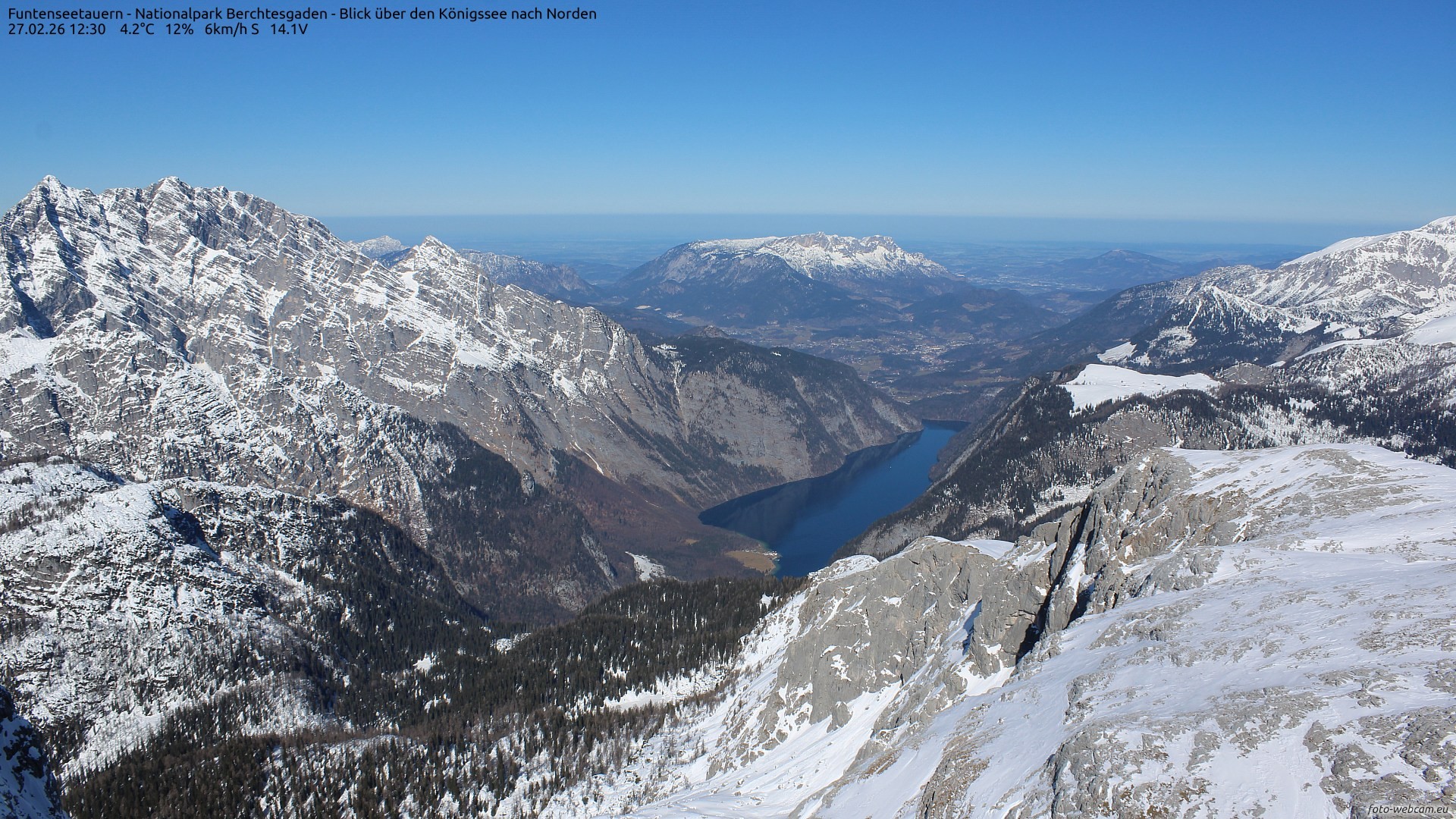
Funtenseetauern Mountain, Berchtesgaden National Park,
Germany (From
Snow Online)
Established in 1978, Nationalpark Berchtesgaden is
Germany’s only Alpine National Park. It's located in the south of Germany, on
its border with Austria, in the municipalities of Ramsau bei Berchtesgaden and
Schönau am Königsee, Berchtesgadener Land in Bavaria. The park is in a
mountainous area south of the town of Berchtesgaden. The park maintains an extensive network of trails
and its area covers 210 km2 (81 sq. mi).
Berchtesgaden National Park experiences a high-altitude, variable climate shaped by both Atlantic oceanic and continental European influences. It is characterized by cold, snowy winters and mild, relatively wet summers, with severe temperature variations depending on the park's massive 2,000-meter vertical altitude change.
In summer (June to August), daytime highs typically average 17°C to 24°C (in the mid-to-upper 60s and 70s
°F). Nights cool down significantly to 10°C to 14°C (into the 50s°F). Winter (November
to February) sees freezing and heavily snowfall. Average daily highs drop
to 0°C to 5°C (into the 30s°F), with nightly lows dipping to around -6°C (into the 20s°F).
Total annual snowfall in Berchtesgaden National Park varies drastically by elevation, ranging from roughly
just 50 cm (20 inches) in the lowest valley regions to as much as between 300 cm and 500 cm (118 to 197
inches) in the high-alpine mountain peaks.
Live camera from the upper station of the six-person
chairlift of the Polana Szymoszkowa Ski Resort in Zakopane. The ski resort is
located on the southern slope of Gubałówka, offering tourists and skiers
beautiful views of the Polish Tatras. From here, you can see the striking group of mountains of Giewont and the peaks of Małołączniak, Kasprowy Wierch, Świnica, Zawrat, Kościelec, Kozi Wierch.
Zakopane is a resort town in southern Poland, at the base of the Tatras Mountains. It’s a popular departure point for winter sports and summertime mountain climbing and hiking.
It lies near Poland's border with Slovakia, in a valley between the Tatra Mountains and Gubałówka Hill. It is connected by rail and road to the provincial capital, Kraków. Zakopane's elevation
is 900 meters (2,954 feet) above sea level.
Zakopane has a humid continental climate. Winters are typically frosty but are relatively sunny for Poland - in fact, Zakopane receives among the most sun in winter in the country. Snow is normally abundant, particularly in the higher altitudes, which makes Zakopane among the most popular ski resorts in Poland.
An interesting note is that the town has seen measurable snow in every month of
the year, other than in July, but snow is still rare in the summer. Summers are cool to warm but rarely get hot.
The all time record cold temperature was −34.1°C (−29.4°F) on February 1, 1956. while the
hottest ever seen temperature here was 32.8°C (91.0°F) on August 8, 2013.
50 of Poland’s most beautiful beaches. View them all year
round on this webcam!
- Austria -
Austria is a country in Central Europe, lying in the
Eastern Alps. It is a federation of nine states, one of which is the capital, Vienna, the most populous city and state. Austria is bordered by Germany to the northwest, the Czech Republic to the north, Slovakia to the northeast, Hungary to the east, Slovenia and Italy to the south, and Switzerland and Liechtenstein to the west. The landlocked country occupies an area of 83,879 km2 (32,386
sq. mi) and has a population of around 9 million.
It is a largely mountainous country because of its location in the Alps. The Central Eastern Alps, Northern Limestone Alps, and Southern Limestone Alps are all partly in Austria. Of the total area of Austria, only about a quarter can be considered low lying, and only 32% of the country is below 500
meters (1,640 ft.). The Alps of western Austria give way somewhat into low lands and plains in the eastern part of the country.
The Grossglockner, or just Glockner, is, at 3,798 meters/12461 feet above the Adriatic, the highest mountain in Austria and the highest mountain in the Alps east of the Brenner Pass. It is part of the larger Glockner Group of the Hohe Tauern range, situated along the main ridge of the Central Eastern Alps and the Alpine divide.
The greater part of Austria lies in the cool/temperate climate zone, where humid westerly winds predominate. With nearly three-quarters of the country dominated by the Alps, the alpine climate is predominant. In the east—in the Pannonian Plain and along the Danube valley—the climate shows continental features with less rain than the alpine areas. Although Austria is cold in the winter (−10°C/14°F to 0°C/
32°F),
summer temperatures can be relatively high. The highest temperature of 40.5°C (105°F)
was reached on 8 August 2013. The nation's lowest temperature ever recorded in Austria was −52.6°C (−62.7°F) on 19 February 1932 at Grünloch Doline.
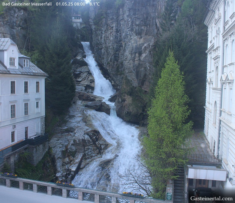
Bad Gastein is a spa town in the St. Johann in Pongau
District. Picturesquely situated in a high valley of the Hohe Tauern mountain
range, it is known for the Gastein waterfall, located in the middle of the city,
at about 1,000 meters (3,300 ft.) above sea level. The waterfall has a drop of 341 meters
(1,119 feet), which rages over rugged cliff faces and through thick forest to tumble into three turquoise pools.
The German word "Bad" means "spa", so in the city's
name, it reflecting the town's history as a health resort. The local Heilstollen (literally 'healing tunnel') thermal spring water earned the town its early fame
and name. Bad Gastein has 17 hot springs that emerge from Graukogel mountain. The water is slightly mineralized, contains radon, and has a temperature of 44
to 47°C |111 to 117°
F. However, the springs at the spas are cooled down to a water temperature of
around 32°C (90°F) (on average) so you won't burn to death.
Gastein is also known as a snow skiing paradise. The town
has a variety of downhill runs for beginners, families and experts on over 66km
|41mi of blue
(easiest |intermediate), 105km | 65mi of red (intermediate) and 10km | 6mi of black (advanced)
ski runs.
Lake Achen (locally known as Achensee), is a lake in Austria, north of Jenbach in Tyrol. Lake Achen is also called "Fjord of the Alps" and "Tyrolean Sea". The largest lake within the federal state, its maximum depth is 133 meters (436 feet).
Together with the Achen Valley, it parts the Karwendel mountain range in the
west from the Brandenberg Alps in the east. An alpine lake, water temperature is accordingly low, rarely above 20°C (68°F). Its size and wind conditions make it suitable for windsurfing. The surrounding areas are popular for winter hiking, cross-country skiing, and snowkiting.
In the above cam photo, the lake is seen on the far left side, just below the
mountain.
Tyrol is a western Austrian state in the Alps that’s
known for its ski resorts, historic sites and folk traditions. The town is
dominated by high mountain ranges, including the Ötztal Alps, the Zillertal
Alps, and the Kitzbühel Alps, with the Grossglockner and other major Alpine
peaks nearby. Its population as of 1 January 2025 was 777,660 and Tyrol's
land size is 12,534 km2 (4,839 sq. mi.).
Tyrol and Lake Achen's climate features an alpine climate with warm, breezy summers and cold, snowy winters. Sheltered and shallower areas of Lake Achen freeze over, but the lake does not freeze over completely.
Because of the lake's immense depth, its continuous water movement, and its cold
water supply, large open sections of the water remain unfrozen throughout the
winter.
In the summer months (June thru August) the area sees mild to warm days ranging between 20°C and 25°C (68°F
to 77°F) . In winter, (December thru February), freezing temperatures average near or below freezing, frequently dropping to -20°C (-4°F).
Lake Achen and Tyrol receives an average annual snowfall of about 80 cm (35 in.) at base elevations.
Au (English pronunciation: [oh]) is a village located in the heart of the Austrian Alps, within the Bregenz Forest of Vorarlberg.
The village, is tucked into the western corner of Vorarlberg, close to the borders of Germany and Switzerland, in western Austria,
and it is surrounded by dramatic alpine scenery and is a popular destination for skiing, hiking, and exploring nature.
40 percent of its 45 km2 (17.4 sq. mi) area is covered with forest, 34.4% of the area is used as alpine pasture (Almwirtschaft) and for other forms of alpine agriculture.
It's population as of 2017 was 1,728.
Au experiences a classic Alpine climate, often classified as a subarctic,
with winters being long, cold, and snowy, and summers short, mild, and pleasant.
Hollandheim, that brings us this webcam, is managed by a Dutch foundation, specializing in organizing affordable, catered summer and winter
vacations for people with disabilities and their companions.
Schmitten Tunnel, towards St.Christoph,
Austria (from ASFINAG)
At around 1,800 meters (5,906 feet), St. Christoph, in the Arlberg region is among the highest Alpine ski resorts.
An exclusive, snow-sure alpine enclave in the famous Ski Arlberg region of
Austria. St. Christoph has 86 lifts within its 304
acres of terrain that is suitable for all levels, including terrain park enthusiasts.
A ski-in/ski-out destination offering direct access to over 300 km (186 miles) of interconnected
ski runs and the renowned off-ski run terrain of the Tyrolean Alps.
St. Christoph (a part of the Ski Arlberg region) sees a
lot of snow each snow season - as it receives an average of 900 to 1,100
centimeters (about 354.33 inches to 433.1 inches) of natural snowfall each year.
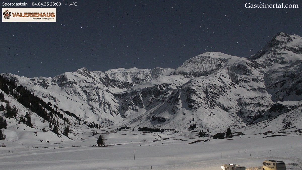
Sportgastein is a village located in the Austrian Alps, the highest ski area in the province of Salzburg. Visitors can reach the resort via the village of Bockstein, which is located beyond Bad Gastein. The 24 slopes of the Sportgastein ski resort cover the Kreuzkogel mountain.
Located at the far end of the valley in the Hohe Tauern National Park, it sits at elevations of 1,590 to 2,650 meters
(5,217 to 8,694 feet), offering dramatic high-alpine terrain, extensive off-piste powder routes, and a long season lasting into spring.
Sportgastein is also a hidden gem for cross-country skiers, winter hikers. A
section of the cross-country ski trails stretches across the center of the above
cam image. To the left, you can see the final section of the red downhill ski
run.
In summer, Nassfeld (the name for the valley floor in Sportgastein) offers hiking opportunities of all difficulty levels and numerous alpine pastures for stopping for refreshments and enjoying a hearty snack, mostly made with locally sourced ingredients.
Sportgastein features a humid continental climate that borders on a subarctic climate due to its high altitude.
Winters are moderately cold with heavy snowfall. Annual snowfall here averages
345 centimeters (136 inches). Freezing levels often drop into the valley, ensuring powdery skiing and long resort seasons.
Summers are mild and refreshing, with warm comfortable daytime highs typically reaching around 21°C
(70°F), and cool, crisp nights in the single digits °C (39°F).
Spring and Autumn are transition months and are highly variable, with spring holding onto snow at high elevations while the valley warms up.
The Gaisberg (aka Mount Gaisberg) is a prominent
mountain in the Austrian Alps located to the east of Salzburg, at an elevation
of approximately 1,288 meters (4,226 feet) above sea level and just a few kilometers from Salzburg's Old Town.
It located in the Salzkammergut Mountains, a range of the Northern Limestone Alps. The Gaisberg is known for its recreational opportunities and panoramic views. It's a popular destination for hiking, mountain biking, and especially paragliding. The mountain offers trails for all skill levels, from easy walks to challenging climbs.
The Gaisberg has a humid continental climate with mild
summers and cool, wet winters. The region is known for its moderate
temperatures, relatively high precipitation, and occasional snowfall. Summers
see average highs in July around 19°C (65°F), while winters are cool, with
January averaging around 0°C (31°F). Salzburg's annual average snowfall total is
243 centimeters
(96 inches).
Different cams from all over Austria, including from Innsbruck, Vienna, Arlberg, Lake Neusiedl, Salzburg, Wachau,
Ischgl and many more destinations.
- Italy -
Italy, a European country with a long Mediterranean
coastline, has left a powerful mark on Western culture and cuisine. In Southern and Western Europe,
it's located on a peninsula that extends into the middle of the Mediterranean Sea, with the Alps on its northern land border, as well as islands, notably Sicily and Sardinia. Italy shares its borders with France, Switzerland, Austria, Slovenia and two enclaves: Vatican City and San Marino. It is the tenth-largest country in Europe, covering an area of 301,340 km2 (116,350
sq. mi), and
the third-most populous member state of the European Union, with a population of nearly 60 million Its capital and largest city is Rome; other major urban areas include Milan, Naples, Turin, Florence, and Venice.
294,020 km2 (113,522 sq. mi) of Italy is land and 7,210 km2 (2,784
sq. mi) is water. Including the islands, Italy has a coastline of 7,600
kilometers (4,722 miles) on the Mediterranean Sea, the Ligurian and Tyrrhenian seas, the Ionian Sea, and the Adriatic Sea. Over 35% of Italian territory is mountainous. The Apennine Mountains form the peninsula's backbone, and the Alps form most of its northern boundary, where Italy's highest point is located on the summit of Mont Blanc (Monte Bianco) at 4,810 meters (15,780
ft.).
Mount Etna in Sicily is the largest active volcanic mountain in Europe.
The climate is influenced by the seas that surround Italy on every side except the north, which constitute a reservoir of heat and humidity.
Conditions on the coast are different from those in the interior, particularly during winter when the higher altitudes tend to be cold, wet, and often snowy. Winter temperatures vary from 0°C (32°F) in the Alps to 12°C (54°F) in Sicily;
while average summer temperatures range from 20°C (68°F) to over 25°C (77°F).
Italy's official language is Italian. In 2020, Italy had 60,317,116 inhabitants. The
population density, of 202 inhabitants per square kilometer (520/sq. mi), is
higher than most West European countries. Italy's population is rapidly aging
and gradually shrinking. Nearly one in four Italians is over 65 and an average age of 46.6.
But Italy also has a substantial flow of immigrants, that started in the
1980s. As of 2010, the foreign-born population was from the following regions: Europe (54%), Africa (22%), Asia (16%), the Americas (8%), and Oceania (0.06%). The distribution of the foreign population is geographically varied: in 2020, 61% of foreign citizens lived in the north, 24% in the center, 11% in the south, and 4% on the islands.
In 2021, Italy had about 5.2 million foreign residents, making up 9% of the population. The figures include more than half a million children born in Italy to foreign nationals but exclude foreign nationals who have subsequently acquired Italian citizenship.
Cinque Terre (Italian:ˈtʃiŋkwe ˈtɛrre) is a string
of centuries-old seaside villages on the rugged Italian Riviera coastline. In
each of the 5 towns, colorful houses and vineyards cling to steep terraces,
harbors are filled with fishing boats within Liguria, in northwest Italy. The Cinque Terre area is a popular tourist destination.
With a steep landscape right up to the cliffs that overlook the Ligurian Sea, paths, trains, and boats connect the villages, as cars can only reach them with great difficulty from the outside via narrow and precarious mountain roads.
The best method of transportation is by train.
Venice, the capital of northern Italy’s Veneto region, is built on
126 small islands in a lagoon in the Adriatic Sea. It has no roads, just canals – including the Grand Canal thoroughfare – lined with Renaissance and Gothic palaces.
Portions of the city are also linked by 472 bridges. In 2020, around 258,685 people resided in greater Venice or the Comune di Venezia, of whom around 51,000 live in the historical island city of Venice (centro storico) and the rest on the mainland (terraferma). Together with the cities of Padua and Treviso, Venice is included in the Padua-Treviso-Venice Metropolitan Area, which is considered a statistical metropolitan area, with a total population of 2.6 million.
The gradual sinking of the surface of Venice, has contributed – along with other factors – to the seasonal Acqua alta ("high water") when the city's lowest lying surfaces may be covered at high tide.
Between autumn and early spring, the city is often threatened by flood tides pushing in from the Adriatic. Six hundred years ago. Venetians protected themselves from land-based attacks by diverting all the major rivers flowing into the lagoon and thus preventing sediment from filling the area around the city. This created an ever-deeper lagoon environment. Additionally, the lowest part of Venice, St Mark's Basilica, is only 64
centimeters (25 inches) above sea level, and one of the most flood-prone parts of the city.
Venice has a mid-latitude, four season humid subtropical climate, with cool, damp winters and warm, humid summers. The 24-hour average temperature in January is 3.3°C (37.9°F), and for July is 23.0°C (73.4°F). Precipitation is spread relatively evenly throughout the year, and averages 748
millimeters (29.4 in); snow falls between late November and early March. During the most severe winters, the canals and parts of the lagoon can freeze, but
because of climate change and the warming trend of the past 30–40 years, the occurrence has become rare.
Ponte di Legno (Camunian: Put de Lègn) is an Italian
comune of 1,729 inhabitants in Val Camonica, province of Brescia, in Lombardy, situated at the confluence of the two source rivers,
Frigidolfo and Narcanello. At an altitude of 1,258 meters/4,127 feet above sea level, the Ponte di Legno
ski area for winter activities has 5 ski lifts, 8 ski slopes and other
connections to the rest of the Ski Area, and for the other seasons, it has
trekking paths, bike trails, and even a high altitude golf course. In Ponte di Legno, the mean yearly temperature
is -0.5°C | 31.1°F. Each year, there is an approximate 1,268 mm | 49.9 inch of precipitation that occurs.
Positano is a small cliffside village and comune on southern Italy's Amalfi Coast
(south of Naples, 56 km/35 mi), in Campania, Italy,
mainly in an enclave in the hills leading down to the coast. It's a well-known holiday destination with a pebble beachfront and steep, narrow streets lined with boutiques and cafes.
The climate of Positano is very mild, of the Mediterranean type; the winters are very warm with minimum temperatures that almost never fall below 6°C (43°F), while the summers are long, warm and sunny but often refreshed by the sea breeze.
- Greece -
Greece, officially the Hellenic Republic, is a country
in southeastern Europe with thousands of islands throughout the Aegean and
Ionian seas. Influential in ancient times, it's often called the cradle of
Western civilization. Located on the southern tip of the Balkan peninsula,
Greece shares land borders with Albania to the northwest, North Macedonia and
Bulgaria to the north, and Turkey to the east. The Aegean Sea lies to the east
of the mainland, the Ionian Sea to the west, and the Sea of Crete and the
Mediterranean Sea to the south. Greece has the longest coastline on the
Mediterranean Basin. The country comprises nine traditional geographic regions,
and has a population of over 10.4 million. Athens is the nation's capital and
largest city. Approximately 80% of Greece consists of mountains or hills, making
the country one of the most mountainous in Europe. Mount Olympus, the mythical
abode of the Greek Gods, culminates at Mytikas Peak at 2,918 meters (9,573 ft.)
elevation, the highest in the country.
The climate of Greece is primarily Mediterranean,
featuring mild to cool, wet winters and hot, dry summers. The mountainous areas and the higher elevations of northwestern Greece as well as in the mountainous central parts of Peloponnese – including parts of the regional units of Achaea, Arcadia, and Laconia – feature an Alpine climate with heavy snowfalls during the winter. Most of the inland parts of northern Greece, in Central Macedonia, the lower elevations of Western Macedonia and Eastern Macedonia and Thrace feature a humid subtropical climate with cold, damp winters and hot, moderately dry summers with occasional thunderstorms. Snowfalls occur every year in the mountains and northern areas, and brief periods of snowy weather are possible even in low-lying southern areas, such as Athens.
Rhodes, the largest of Greece’s Dodecanese islands, is
their historical capital; and is the ninth largest island in the Mediterranean
Sea. It's known for its beach resorts, ancient ruins and remnants of its
occupation by the Knights of St. John during the Crusades.The principal town of
the island and seat of the municipality, it had 50,636 inhabitants in 2011. In 2022, the island had a population of 125,113 people. It is located northeast of Crete and southeast of Athens.
The island of Rhodes is shaped like a spearhead, 79.7 km (49.5 mi) long and 38 km (24 mi) across at its widest, with a total area of approximately 1,400 km2 (541 sq mi) and a coastline of approximately 220 km (137 mi). Limestone is the main bedrock.
The city of Rhodes is located at the northern tip of the island, as well as the
site of the ancient and modern commercial harbours. It is situated 363 km (226 mi) east-southeast from the Greek mainland, and 18 km (11 mi) from the southern shore of Turkey. Mount Attavyros, at 1,216 m (3,990 ft), is the island's highest point of elevation.
Elli beach is one of the most lively and visited beaches on Rhodes, located at the northern most part of the island and is considered to be the official beach of Rhodes town.
Rhodes, the largest of Greece’s Dodecanese islands; it is the ninth largest island in the Mediterranean Sea.
It's known for its beach resorts, ancient ruins and remnants of its occupation by the Knights of St. John during the Crusades. The principal town of the island and seat of the municipality is the city of Rhodes, home to 50,636 inhabitants according to the 2011 census. By 2022, the island’s population had grown to 125,113 people.
Rhodes is located northeast of Crete and southeast of Athens. Its highest elevation (Attavyros)
is at 1,216 meters (3,990 feet)
and lowest elevation being 0 meters (0 feet).
Rhodes has a hot-summer Mediterranean climate with mild winters and hot summers. The South East of the island experiences a significantly warmer climate with Lindos, registering a mean annual temperature of around 22.0°C (71.6°F), making it the warmest area in Greece.
Moreover, according to the Hellenic National Meteorological Service, South East
Rhodes records the highest mean annual sunshine in Greece with over 3,100 hours. The Rhodes International Airport in coastal Paradeisi has never dropped below 1.2 °C (34.2 °F).
- Bosnia and Herzegovina -
For Bosnia and Herzegovina, sometimes known as Bosnia-Herzegovina and informally Bosnia,
it is a country in Southeast Europe. Situated on the Balkan Peninsula, it borders Serbia to the east, Montenegro to the southeast, and Croatia to the north and southwest.
According to the 1991 census, Bosnia and Herzegovina had a population of 4,369,319, while the 1996 World Bank Group census showed a decrease to 3,764,425.
Brijesce: Intersection Briješće, Sarajevo, Bosnia and Herzegovin (From Meteoblue)
Brijesce settlement is located in the city of Sarajevo, Bosnia and Herzegovina. A peaceful, green residential settlement and local community in the Novi Grad Municipality on the outskirts of the capital. It is characterized by hilly landscapes, authentic Bosnian hospitality, and provides easy road access to the historic Baščaršija district via local buses and minibuses.
Sarajevo has an oceanic climate bordering on a humid continental climate. The average yearly temperature is 10°C (50°F), with January (−0.5°C (31.1°F) on average) being the coldest month of the year and July (19.7°C (67.5°F) on average) the warmest.
The highest recorded temperature was 40.7°C (105°F) on 19 August 1946 and on 23 August 2008, while the lowest recorded temperature was −26.2°C (−15.2°F) on 25 January 1942. On average, Sarajevo has seven days where the temperature exceeds 32°C (89.6 °F) and four days where the temperature drops below −15°C (5°F)
per year.
The cloudiest month is December (with 75% average cloud cover), while the clearest is August (37%). Moderate precipitation occurs fairly consistently throughout the year, with an average 75 days of rainfall.
As far as snowfall, it sees 54 days a year with snow from late October to early
May, with December thru February the snowiest months. On average it sees 110 cm/44 inches,
but their snowfall accumaation records are not well kept at all, and nothing
shows for the most ever in a season.
- Hungary -
Hungary is a landlocked country in Central Europe. Its capital
is Budapest and it's bisected by the Danube River. Spanning much of the Carpathian Basin, it is bordered by Slovakia to the north, Ukraine to the northeast, Romania to the east and southeast, Serbia to the south, both Croatia and Slovenia to the southwest, and Austria to the west.
Its total area
is 93,034 km2 (35,924 sq. mi).It had a population
in January 2026 estimated to be 9,489,000.
Its cityscape is studded with architectural landmarks from Buda’s medieval Castle Hill and grand neoclassical buildings along Pest’s Andrássy Avenue to the 19th-century Chain Bridge. Turkish and Roman influence on Hungarian culture includes the popularity of mineral spas, including at thermal Lake Hévíz.
Hungary has a temperate seasonal climate, with generally warm summers with low overall humidity levels but frequent rain showers and cold snowy winters. Average annual temperature is 9.7°C (49.5°F). Temperature extremes are 41.9°C (107.4°F)
reached on 20 July, 2007 at Kiskunhalas and −35°C (−31.0°F) set on 16 February 1940 at Miskolc. Average high temperature in the summer is 23 to 28°C (73 to 82°F) and average low temperature in the winter is −3 to −7°C (19
to 27°F). The average yearly rainfall is approximately 600 millimeters (23.6 inches),
with seasonal snowfall being an average of about 14 cm (6 inches) to about an annual average
of approximately 630 millimeters (25 inches) in the mountains.
Ságvár, Hungary is a village in Somogy county, Hungary.
It has an total area
of 38.44 km2 (14.84 sq. mi) and a population (in 2017)
of
1,787. According to the local legends the settlement was named after a aristocrat called Ság who had a castle there.
Madarles - Live Bird Cams show many bird nests and feeders
in Hungary with their webcams. You can see how different species of birds lay
their eggs and then watch how the hatchlings grow up with each passing day.
- Serbia -
Serbia, officially the Republic of Serbia,
is a landlocked country in Southeast and Central Europe. Located in the Balkans, it borders Hungary to the north, Romania to the northeast, Bulgaria to the southeast, North Macedonia to the south, Croatia and Bosnia and Herzegovina to the west, and Montenegro to the southwest. Serbia claims a border with Albania through the disputed territory of Kosovo. Serbia has about 6.6 million inhabitants, excluding Kosovo
and has been continuously inhabited since the Paleolithic Age (aka the old Stone
Age). Its capital Belgrade is also the largest city.
The language here is intresting, with
the official language being Serbian, native to 88% of the population. The
intresting part is that Serbian is the only European language with active digraphia
(the use of more than one writing system for the same language), using both Cyrillic and Latin alphabets. Serbian Cyrillic is designated in the Constitution as the "official script". A survey from 2014 showed that 47% of Serbians favour the Latin alphabet, 36% favour the Cyrillic one and 17% have no preference.
View of the crossroads of Milorad Jovanović and Pešterska the heart of Sjenica. The Sjenica area
has been inhabited since prehistoric times. The population of the municipality, according to 2022 census, is 24,083, while the town has a population of 12,989.
The town sits at an elevation of 1,026 meters (3,366 feet), making it one of the highest towns in Serbia and the Balkans, and its land covers an area of
1059 km² (409 mi²).
According to the Köppen-Geiger climate classification, it has a humid continental climate with freezing and not so humid winters, and with warm and humid summers, but with cold nights. The town itself extends on the right side of the Uvac river and is located along the Grabovica river, in the spacious Sjenica basin. Sjenica has a warm-summer
and is known in Europe as one of the coldest inhabited places. Winters in Sjenica are long and cold, and low temperatures can sometimes last for days.
They have official weather records here that don't always jive with some other
official sources. For example, the coldest ever temperature is officially listed
as taking place in January, in the 1990s, at −35.6°C (−32.1°F), but no date was
given. Yet in January 2005, the unofficial lowest temperature in Serbia was recorded in Sjenica,
at −42°C (-43.6°F). This reading was taken at the official weather site but it's
noted today as the unofficial lowest reading, with the −35.6°C reading from the
1990s still listed as the official coldest reading ever. So, what does that
mean? Anyway, there seems to be only one hottest ever reading, and that was set
in August sometime between 1961 and 2020 at 36.2°C (97.2°F). Seems they just
didn't bother to keep except dates at their weather station. The town also
averages 796.6 mm (31.4 in) of precipitation a year in rain and snow. It also
averages 106 days of rain and 60 days a year of snow.
Belgrade is the capital of the southeast European country of Serbia. Its most significant landmark is the Beogradska Tvrđava, an imposing fortress at the confluence of the Danube and the Sava rivers. The fort is a testament to the city’s strategic importance to the Roman, Byzantine, Ottoman, Serbian and Austrian empires, and it's now the site of several museums as well as Kalemegdan, a vast park.
Beograd (pronounced beh-oh-grad) is the local Serbian name
for the city, meaning "White City".
Belgrade is the anglicized version of the name used in English and most international languages.
According to the 2022 census, the population of Belgrade city proper stands at 1,197,114, its contiguous urban area has 1,298,661 inhabitants, while the population of the city's administrative area (which roughly corresponds to its metro area) totals 1,682,720 people.
It's one of the oldest continuously inhabited cities in Europe. One of the most important prehistoric cultures of Europe, the Vinča culture, evolved within the Belgrade area in the 6th millennium BC.
Belgrade lies 116.75 meters (383.0 feet) above sea level.
It has a humid subtropical climate bordering on a humid continental climate and
a uniformly spread precipitation. Monthly averages range from 1.9°C (35.4°F) in January to 23.8°C (74.8°F) in July.
The highest recorded temperature in Belgrade was 44°C (111°F) on 24 July 2007, while the lowest temperature was −26°C (−15°F) on 10 January 1893.
The city receives an average annual snowfall of about 40 centimeters (16 inches).
- Romania -
Romania is a southeastern European country known for the forested region of Transylvania, ringed by the Carpathian Mountains. Its preserved medieval towns include Sighişoara, and there are
also many fortified castles. Bucharest
is the country’s capital and largest city. It borders Ukraine to the north and east, Hungary to the west, Serbia to the southwest, Bulgaria to the south, Moldova to the east, and the Black Sea to the southeast. It has a mainly continental climate, and an area of 238,397 km2 (92,046 sq mi) with a population of 19,053,815 people (as
of 2021), making Romania the twelfth-largest country in Europe. The Carpathian Mountains dominate the center of Romania, with 14 mountain ranges reaching above 2,000 m/6,600 ft
- with the highest being Moldoveanu Peak at 2,544 m/8,346 ft.: 11 They are surrounded by the Moldavian and Transylvanian plateaus, the Pannonian Plain and the Wallachian plains.
Romania also has one of the largest areas of undisturbed forest in Europe, covering almost 27% of its territory.
Because of its distance from open sea and its position
on the southeastern portion of the European continent, Romania has a climate
that is continental, transitioning into humid subtropical (locally often "warm oceanic") on the eastern coast, influenced by polar intrusions, and therefore characterized by harsh winters. The mountain ranges of the Carpathian arc have a cool mountain climate with high humidity throughout the year.The highest temperature ever recorded in Romania was 44.5°C (112.1°F) in 1951 at the Ion Sion weather station in Brăila County.
The lowest temperature ever recorded in Romania was -38.5°C (-37.3°F) in 1942, near Brașov.
Rainfall, while adequate throughout the country, decreases from west to east and from mountains to plains. Some mountainous areas receive more than 1,010 mm (39.8 in) of precipitation each year.
Castelul Bran - Dracula's Castle - Casa din Bran, Transylvania, Romania (From
See Transylvania)
Transylvania is Romania's best-known region, located in central Romania. It's known for medieval towns, mountainous borders and castles like Bran Castle, a Gothic fortress associated with the legend of Dracula. The city of Brașov features Saxon walls and bastions.
After being a part of Hungary in the 11th–16th centuries, it
became an autonomous principality within the Ottoman Empire (16th–17th century) and then once again became part of Hungary at the end of the 17th century. It was incorporated into Romania in the first half of the 20th century.
Bran Castle, is a medieval stronghold in the Transylvanian Alps (Southern Carpathian Mountains) of Brașov county, central Romania. Popularly identified with the fictional Castle Dracula, Bran Castle is one of Romania’s top tourist attractions.
Construction was begun on it in 1377, after King Louis I of Hungary authorized it as a bulwark against northward expansion of the Ottoman Empire. The castle was completed by 1388.
Bran Castle is often associated with the vampire Count Dracula. The Romanian castle resembles Castle Dracula, as described in Bram Stoker’s novel
Dracula (published in 1897), in that both stand on rocky cliffs and
command spectacular views. But Stoker, an Irish writer, is not known to have
ever visited Transylvania. Vlad the Impaler (real name Vlad III also
known as Vlad Dracula), the 15th-century governor/princes of Wallachia, is most
closely identified with Stoker’s Dracula, but he never ruled Bran Castle,
although some sources claim that he was held in exile there for two months in
1451. Yet this evil executioner/murder from Romania,
is believed to be Stoker’s inspiration for the story's Dracula.
The castle became a museum in 1956 and still is today. BTW, the castle ready does
have a secret passage. The secret corridor connects the first and third floors, albeit it is no longer secret.
But it wasn't known about for hundreds of years. The entry to the secret corridor was hidden behind an antique fireplace. It was discovered in the 1920s while Queen Marie was renovating the castle.
Brasov City, Ceasu Rau, Transylvania, Romania (FromSee Transylvania)
Brasov is the largest city within Transylvania, Romania. According to the 2021 census, it has a population of 237,589 inhabitants. In Brașov, summer lasts about 50 days, and winter lasts about 90 days. The usual summer temperature is between 22°C
(72°F) and 27°C (81°F), and the winter temperature between -18°C (-1°F) and -2°C
(28°F). The ski season here lasts about 71 days.
- Georgia -
So, where do we list the country of Georgia? Under
Europe or Asia? Well, it is officially a transcontinental country, with the vast majority of its landmass and its capital, Tbilisi, situated in Western Asia. Geographically, only a small fraction (between 5% to 10%) of its northern territory extends across the Greater Caucasus Mountain
into Eastern Europe. So it's in Asia, right? No, that's not how we actually
lists here. We aren't at all strict when it comes to things like geography. Culturally, historically, and politically, the country
today is strongly integrated with Europe. It is officially recognized as an EU candidate country and is widely considered part of Europe in modern geopolitical contexts.
Plus even more important, it's where the people who live here claim they live.
Georgia was once a part of the Soviet Union, but it was
the first non-Baltic republic of the Soviet Union to officially declare
independence On 9 April 1991. It is a country in the Caucasus region on the coast of the Black Sea.
It is bordered to the north and northeast by Russia; to the west by the Black Sea, to the south by Turkey and Armenia, and to the southeast by Azerbaijan. It has a population of 3,657,000
(as of 2024 census), of which over a third live in Tbilisi. It's total area
covers 69,700 km2 (26,900 sq. mi). The country has an average elevation of 1,432 meters (4,698 feet) above sea level. Its highly mountainous terrain ranges from the alpine heights of the Greater Caucasus
(2,000 meters to 3,000 meters [approx. 6,500 to 9,800 feet]) in the north to the fertile coastal valleys of the Black Sea
(100 to 150 meters [330 to 500 feet]).
Much of western Georgia climate is in the humid
subtropical zone with annual precipitation ranging from 1,000–2,500 mm (39–98
in), reaching a maximum during the Autumn months. In the winter, snowpack often
exceeds 2 meters (or 200 cm; 79 inches or 6.5 feet) in many regions. Eastern Georgia has a transitional climate from humid subtropical to continental. The region's weather patterns are influenced both by dry Caspian air masses from the east and humid Black Sea air masses from the west.
Snow is rare here and typically melts quickly. The region averages only about
12.7 centimeters (5
inches) per season.
Rustavi (Georgian: რუსთავი [ɾustʰavi]) is a city in the
southeast of Georgia, in the region of Kvemo Kartli and 20 kilometer (12 miles)
south of the capital Tbilisi. It has a population of 127,154 (in January 2024),
making it the third most populous city in Georgia. It is one of the Georgia's
older towns, as a city it was founded at least dating back to the 5th to 4th centuries B.C.
Rustavi has a humid subtropical climate with hot summers and relatively cold winters.
Mean daily temperatures' maximum and minimums are a high of 19.3°C (66.8°F) and a low of 8.6°C (47.5°F).
Average yearly precipitation is 485 millimeters
(19.2 inches). The city averages a total accumulation of snow per winter of
about 8.4 centimeters (3.5 inches).
First, yes, Greenland is geologically part of the North American continent, specifically sitting on the North American tectonic plate.
But it's an autonomous territory of Denmark and considered part of Europe in terms of political and cultural ties.
So, it's physically located on the North American landmass
and technically the only part of Europe that sits in North America (and
no, Iceland is not part of North America,
while it straddles the Mid-Atlantic Ridge, the majority of Iceland's landmass is on the Eurasian
Plate, making it a part of Europe).
Facts about Greenland: It is the world's largest island
(bigger than Mexico, at 2.16 million square kilometres, or 833,981 square miles), that is not a continent. Almost 80% of it is covered by the ice cap and glaciers. It has been populated for 5,000
years, by people from the Arctic region and Europe. This self-ruling Danish territory, voted in a referendum to leave the European Communities, a precursor to the EU, in 1982 and formally left the bloc in 1985 — though most of its roughly 60,000 citizens are Danish and therefore still EU citizens. Greenland has a very small population, around 56,000 people. Most residents live along the coast in towns and settlements.
Greenland's climate is predominantly Arctic,
characterized by long, cold, and dark winters and short, cool summers. The
island's vast ice sheet covers most of the land, influencing the climate
significantly. But the Gulf Stream moderates winter temperatures in coastal
areas, making them milder than expected for their latitude.The highest
temperature ever recorded in Greenland was 26.4°C (79.3°F) on July 6, 2008. This record was observed at an unspecified location. Another instance of a record high temperature was in 2021, with 23.6°C (74.5°F) reported at the Tasiilaq weather station. The warmest month in
Greenland is July, with average temperatures in the south reaching around 60
degrees Fahrenheit (16 degrees Celsius). The Klinck weather station holds the
record for the coldest place in the Arctic Circle. Located in central Greenland,
it beat the previous record low held by Oymyakon Russia by around 2 degrees in
December 1991, reaching -69.6°C (or -93.4°F). Despite these cold temperatures, much of
Greenland’s ice is melting rapidly because of climite change. The most snow ever recorded in Iceland was 279 centimetersm (approximately 9.2 feet) measured at the Skeiðsfossvirkjun power plant in North Iceland on March 19, 1995.