
Worldwide Webcams
- Asia/Far East -
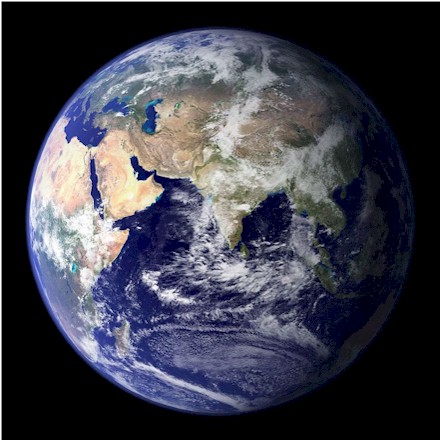
Asia (/ˈeɪʒə/ AY-zhə, UK also /ˈeɪʃə/ AY-shə) is the largest continent in the world by both land area and population. It covers an area of more than 44,000,000 km2 or 16,988,495 square miles, about 30% of Earth's total land area and 8% of the Earth's total surface area. The continent, which has long been home to the majority of the human population, was the site of many of the first civilizations. Its 4.7 billion people constitute roughly 60% of the world's population. It is bounded on the east by the Pacific Ocean, on the south by the Indian Ocean, on the north by the Arctic Ocean, and to the west by Europe. Asia is a region where various independent cultures coexist rather than sharing a single culture, and the boundary between Europe is somewhat arbitrary and has moved since its first conception in the classical era.
Most of our webcams on this page come from Asia's Far East. The Far East is used to refer to all the countries of Eastern Asia, including China, Japan, North and South Korea, Myanmar, Thailand, Laos, Cambodia, Vietnam, and Malaysia.
Russia is a transcontinental country located in both Europe and Asia. The country spans the massive Eurasian landmass, with the Ural Mountains traditionally serving as the dividing line between the two continents. It covers nearly 30% of the Asian continent's total land area. Since its so large, Russia has it's own cam page.
- Our first 2 cams comes from Turkey -
Turkey, officially the Republic of Türkiye, is a country mainly located in in West Asia, with a smaller part in Southeast Europe. Yes, Turkey spans two continents, bridging the west and the east. The European side is located on approximately 3% of Turkey's landmass. This region borders Greece and Bulgaria and includes a part of Istanbul, the region's largest city. On the Asian Side (Anatolia) of Turkey, about 97% lies in Asia. Istanbul, Turkey, connects Europe and Asia and is split by the Golden Horn and the Bosphorus Strait which links the Sea of Marmara to the Black Sea. The country is home to over 86 million people. Its total area is 783,562 km2 (302,535 sq mi), with 2% of that water.
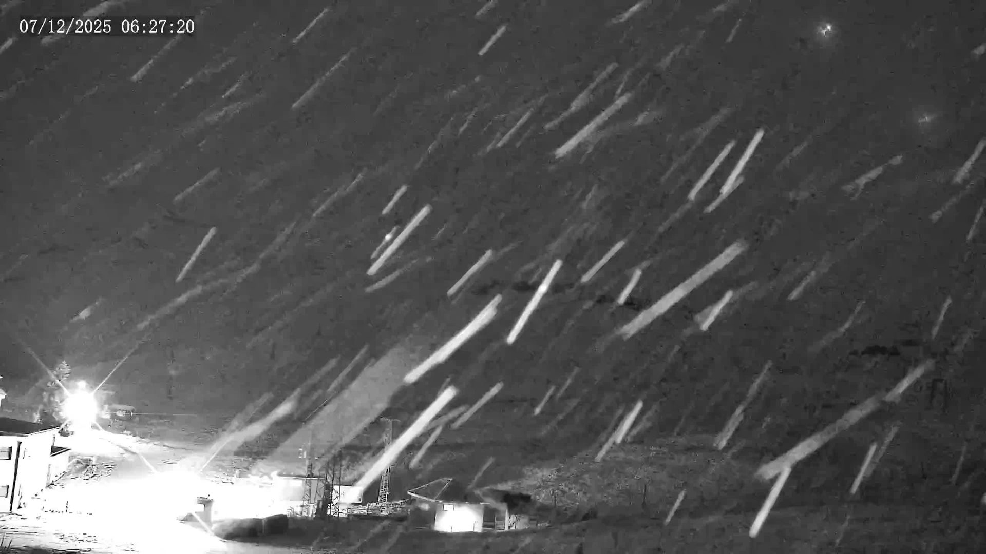
Saklıkent Ski Resort , Antalya, Turkey
(from Saklıkent Ski Resort)
Saklıkent is a short-season ski resort 50 km west of the town of Antalya, in the Beydag mountain range. Saklıkent ski resort offers you the chance to ski and swim in the sea on the same day. The skiing at Saklıkent is on the lower slopes of Mount Bakırlı, 2,547 meters (8,356 feet) in height, allowing the season to often extend well into April. Two T-bars with capacities of 240 and 340 people per hour, service two ski runs rated with difficulty levels of easy and medium.
Saklıkent Ski Resort typically sees average snow depths between 100 and 230 centimeters (roughly 40 to 91 inches) during the season. Despite its location near the warm Mediterranean coast, the resort often has significant snow, with a snowpack occasionally in some years, reaching up to 5 meters (195 inches) at its peak.

Olympos Cable Car, Mt. Olympos, Turkey
(from
windy.com)
The Olympos Aerial Tram, aka Olympos Cable Car, is an aerial lift of tramway type located in Antalya Province, southern Turkey, serving the peak of Mount Olympos at an altitude of 2,365 meters (7,760 feet) from Kemer. It went into service on June 17, 2007. With its length of 4,359 meter (14,301 feet), it is one of the longest passenger-carrying aerial tramway lines in the world. The base station is located between the towns of Çamyuva and Tekirova in Kemer district at 726 meters (2,382 feet) altitude.
Olympos Cable Car takes you on a pleasant journey to the summit of Tahtalı Mountain where you can enjoy unique views and relax in clean mountain air. If you're looking for adventure, you can soar into the sky paragliding. Mt. Olympos is situated within the Beydağları Coastal National Park. Snow covers the peaks for roughly 9 months of the year. High winds are a constant presence, creating a much lower, wind-chill-driven temperature year-round.
- Next cam comes from Nepal, in South Asia -
View from
Annapurna Mountain, in the Himalayas of Nepal
(From Hotel
Annapurna View Sarangkot)
Nepal has a diverse geography, including fertile plains, subalpine forested hills, and eight of the world's ten tallest mountains, including Mount Everest, the highest point on Earth, at 8,849 meters (29,032 feet). Its capital is Kathmandu and its population was 29.69 million (in 2023). It is a landlocked country bordered by China to the north and India to the south, east, and west. It is mainly situated in the Himalayas, but also includes parts of the Indo-Gangetic Plain. It is the oldest nation-state of South Asia and is generally considered a poor country, particularly when compared to many other nations. While it has experienced economic growth, it remains a low-income nation with a significant portion of its population living below the poverty line.
Hinduism is the predominant religion of the country, yet in the middle of the first millennium BC, Gautama Buddha, the founder of Buddhism, was born in Lumbini, in southern Nepal. Parts of northern Nepal are intertwined with the culture of Tibet. The country was never colonized but served as a buffer state between Imperial China and British India. Parliamentary democracy was introduced in 1951 but was twice suspended by Nepalese monarchs, in 1960 and 2005. The Nepalese Civil War in the 1990s and early 2000s resulted in the establishment of a secular republic in 2008, ending the world's last Hindu monarchy. The Constitution of Nepal was adopted in 2015, affirms the country as a federal parliamentary republic divided into seven provinces.
Nepal is of roughly trapezoidal shape, about 800 kilometers (500 miles) long and 200 kilometers (120 miles) wide, with an area of 147,516 km2 (56,956 sq. mi). It is divided into three principal physiographic belts known as Himal–Pahad–Terai. Himal is the mountain region containing lots of snow and situated in the Great Himalayan Range; making up the northern part of Nepal. Pahad is a mountain region that does not generally contain snow. The mountains here vary from 800 to 4,000 meters (2,600 to 13,100 feet) in altitude, with progression from subtropical climates below 1,200 meters (3,900 ft.) to alpine climates above 3,600 meters (11,800 ft.). The Tarai region, is in the Lower Himalayan Range, reaching 1,500 to 3,000 meters (4,900 to 9,800 ft.), and is the southern limit of this region, with subtropical river valleys and "hills" alternating to the north of this range.
Nepal's climate is highly variable due to its extensive range in altitude and geographic location. It experiences distinct seasons, including spring, monsoon/summer, autumn, and winter, each with unique weather patterns. The Tarai region in the south experiences subtropical monsoon conditions, while the mid-mountain areas have a warm temperate climate, and the higher Himalayan regions have cool temperate to alpine climates. At altitudes above 4,877 meters/16,000 feet, the temperature is always below freezing and with the surface covered by snow and ice. Rainfall is ample in the eastern portion of the Tarai (which receives from 1,800 to 1,900 millimeters/70 to 75 inches a year at Biratnagar) and in the mountains, but the western portion of Nepal is drier (where 851 millimeters/33.5 inches a year fall at Mahendranagar).
In Kathmandu Valley, average temperatures range from 10°C (50°F) in January to 26°C (78°F) in July, and the lowest and highest temperatures recorded have been -3°C and 37°C (27° and 99°F). The average annual rainfall is about 1,397 millimeters/55 inches, most of which falls in the period from June to September. At Pokhara the temperature ranges from 4°C (40°F) in January to approximately 38°C (100°F) in June, just before the monsoon. In winter, temperatures during the day rise to 21°C (70°F), creating pleasant conditions, with cool nights and warm days. Because warm rain-bearing monsoon winds discharge most of their moisture as they encounter the Annapurna range, rainfall is quite heavy (about 2,540 mm/100 in) in the Pokhara Valley. As far as snowfall and the weather in general at Mount Everest, it receives a significant amount each year, with the summit's snowpack varying greatly from 1.5–6 meters (5–20 feet). The snow depth on the summit is estimated to be around 9.5 meters (31.1 feet) on average. However, this depth fluctuates, with the snow level being highest in September after the monsoon and lowest in May after being depleted by winter winds. In addition to being the highest place on Earth, the peak of Mount Everest is the windiest and also bitterly cold. Hurricane-force winds can batter the summit, creating wind chill temperatures as low as -70°C/-90°F. This is cold enough to cause frostbite on exposed skin almost instantly. The warmest recorded temperature on the summit of Mount Everest is -16°C (3°F). July is the warmed month here, when the average daytime temperature on the summit can be around -2°F (-19°C). However, temperatures can drop significantly during the coldest months, like January, with average temperatures of -36°C (-33°F) and potentially as low as -60°C (-76°F).
- Our next two cams come from Koh Samui,
Thailand -
Hooters Cam, Chaweng, Koh Samui, Thailand
(From
The Real Samui)
Koh Samui (or Ko Samui) (Thai: เกาะสมุย, pronounced [kɔ̀ʔ sā.mǔj]), often locally shortened to Samui, is Thailand’s second largest island, with an area of 228.7 square kilometres (88.3 sq mi), and located in the Gulf of Thailand off the east coast of the Kra Isthmus. It's known for its palm-fringed beaches, coconut groves and dense, mountainous rainforest, plus luxury resorts and posh spas. Samui's elevation is as low as sea level to as high as 635 m (2,083 ft). The landmark 12m/39ft-tall golden Big Buddha statue at Wat Phra Yai Temple is located on a tiny island connected to Ko Samui by a causeway. The island is believed to be first inhabited about 15 centuries ago and settled by fishermen from southern China. It appears on Chinese maps dating back to 1687, under the name Pulo Cornam.
Ko Samui has a tropical monsoon climate, and is warm and humid for most of the year. It receives about 1,960 mm (77.2 in) of rain per year. It's population as of 2019 was 70,059.
- Next can from Vietnam -
Công Trình bệnh viện , Da Nang, Vietnam
(from Phát Triển Đà Nẵng)
Vietnam, officially the Socialist Republic of Vietnam (SRV), is a country at the eastern edge of mainland Southeast Asia, with an area of about 331,000 square kilometres (128,000 sq. mi) and a population of over 100 million, making it the world's fifteenth-most populous country. One of two Marxist–Leninist states in Southeast Asia, Vietnam shares land borders with China to the north, and Laos and Cambodia to the west. It shares maritime borders with Thailand through the Gulf of Thailand, and the Philippines, Indonesia, and Malaysia through the South China Sea. Its capital is Hanoi and its largest city is Ho Chi Minh City (aka Saigon).
Da Nang is a coastal city in central Vietnam known for its sandy beaches and history as a French colonial port. This live webcam overlooks Nguyễn Văn Linh, a busy financial route in Hải Châu district, in central Vietnam. This busy street takes you to the Dragon Bridge (Cầu Rồng) across the Hàn River, which you have a glimpse in the background, and a stretch of APEC Park (Công viên APEC Vietnam 2017), on the right-hand side of the image. Da Nang is the fifth most populated city in Vietnam as well as a commercial and educational hub in the central region of Vietnam.
Da Nang has a tropical monsoon climate with two seasons: a typhoon and wet season from September to December and a dry season from January to August. Temperatures have an annual average of around 26°C (79°F). Cold waves can occasionally occur, although they are of short duration. Temperatures are highest between June and August with mean temperatures of 28 to 30°C (82 to 86°F), and lowest between December and February (mean temperature of 18 to 23°C (64 to 73°F). Highest temperature ever was set in May at 41.5°C (106.7°F). Coldest was reached in December at 9.2°C (48.6°F). Precip wise, this area sees a lot of rain, with the average per year being 2,205mm (86.81 inches) over 139 days.
- Next 4 cams come from Japan, the first 2 from Tokyo -
東京 新宿 歌舞伎町 ライブ /Shinjuku Kabukicho, Tokyo, Japan
(From
Kabukicho Live Channel II)
Info on Tokyo is down below.
お台場・レインボーブリッジ - 首都高 ライブカメラ Rainbow Bridge - Tokyo, Japan
(from
FNNプライムオンライン)
Tokyo (/ˈtoʊkioʊ/; Japanese: 東京, Tōkyō, [toːkʲoː]), is the capital of Japan, and one of the most populous cities in the world, with a population of over 14 million residents as of 2023 and the second-most-populated capital in the world. The Greater Tokyo Area, which includes Tokyo and parts of six neighboring prefectures, is the most-populous metropolitan area in the world, with 41 million residents as of 2024. It's located at the head of Tokyo Bay, and is part of the Kantō region on the central coast of Honshu, Japan's largest island.
The majority of Tokyo lies in the humid subtropical climate zone, with hot, humid summers and mild to cool winters with occasional cold spells. The region, like much of Japan, experiences a one-month seasonal lag. The warmest month is August, which averages 26.9°C (80.4°F). The coolest month is January, averaging 5.4°C (41.7°F). The record low temperature was −9.2°C (15.4°F) on January 13, 1876. The record high was 39.5°C (103.1°F) on July 20, 2004. The record highest low temperature is 30.3°C (86.5°F), on August 12, 2013, making Tokyo one of only seven observation sites in Japan that have recorded a low temperature over 30°C (86.0°F).
Tokyo often sees typhoons every year, though few are strong. The wettest month since records began in 1876 was in October 2004, with 780 millimeters (30 in) of rain. Annual rainfall averages nearly 1,600 millimeters (63.0 in), with a wetter summer and a drier winter. The growing season in Tokyo lasts for about 322 days from around late-February to early January.
Snowfall is rare here, and occurs at most once a year. The largest snowfall on record to take place in Tokyo was 27 cm (or 10.6 inches) in February of 2014, which was the most in over 45 years at that time. While other parts of Japan have experienced significantly more snow (see the cam below this one), this 2014 event stands as the heaviest snowfall in recent memory for the Tokyo metropolitan area itself.
Sapporo Hokkaido Japan
(From
Hokkaido Kurashi no Yomimono)
Sapporo, capital of the mountainous northern Japanese island of Hokkaido. As of July 31, 2023, the city has a population of 1,959,750, making it the largest city in Hokkaido and the largest north of Tokyo. Sapporo has a humid continental climate, with a wide range of temperature between the summer and winter. Summers are generally warm and humid, winters are cold and very snowy, with an average snowfall of 4.79 m (15 ft 9 in) per year.
松本城ライブカメラ#1「本丸庭園」/Matsumoto Castle, Matsumoto, Nagano Prefecture, Japan
(From
【公式】国宝松本城 / National Treasure "Matsumoto Castle")
Matsumoto Castle (松本城, Matsumoto-jō), originally known as Fukashi Castle, is one of Japan's premier historic castles. Current structures date from 1594; 431 years ago. The Castle maintains its original wooden interiors and external stonework. It is listed as a National Treasure of Japan, and is one of the twelve surviving tenshu in Japan. The Japanese Alps Range (日本アルプス, Nihon Arupusu Range) are seen in the distance on clear days.
- Next up, China -
Hong Kong, China
(from
HK360VR)
Hong Kong's city scape cam. The city has 7.5 million residents (as of 2024) of various nationalities in a 1,104-square-kilometre (426 sq. miles) territory. Hong Kong maintains separate governing and economic systems from that of mainland China under the principle of one country, two systems. It's highest elevation is at Tai Mo Shan, at 957 meters (3,140 feet), with it's lowest spot being sea level at the China Sea.
Hong Kong has a very humid subtropical climate, characteristic of southern China, despite being located south of the Tropic of Cancer, although closely bordering on a tropical climate. Historic temperature extremes show the highest and lowest recorded temperatures are 39.0°C (102°F) at Wetland Park on 22 August 2017, and −6.0°C (21.2°F) at Tai Mo Shan on 24 January 2016. Winters are short, mild and usually sunny until around February when the most cloud cover days occur. Snowfall is extremely rare in Hong Kong; the last reported instance was in Tai Mo Shan in 1975.
- Taiwan -
Sanxiantai Island, Taiwan
(From
東部海岸國家風景管理處)
Sanxiantai Island is a scenic island located on Taiwan‘s eastern coast. It used yo be connected to Taiwan until gradual erosion cut the neck that connected the 2 lands, thus becoming an offshore island. Years ago, tourists who used to visit this island could only reach it during low tide. Then in 1987, the government completed the eight cross-sea arch bridge that crosses over to the island. It was designed in the shape of waves, like a prostrate sea dragon and connects Sanxiantai with Taiwan Island. It has become the most famous landmark on the East Coast.
- Finally, our last cam comes from the Philippines -
Live Street BBQ, Davao City, Philippines
(From Edge Babor)
- Map of Asia -
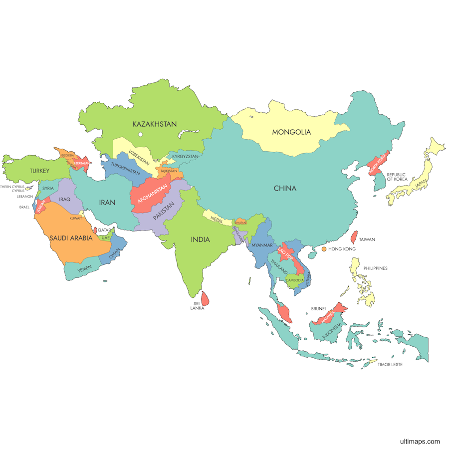
- World Map Highlighting Far East Asia -

| Worldwide Webcams Home Page | Colorado Web Cams | New York Webcams | New York City Webcams | Long Island Webcams |