Worldwide Webcams
Antarctica Webcams
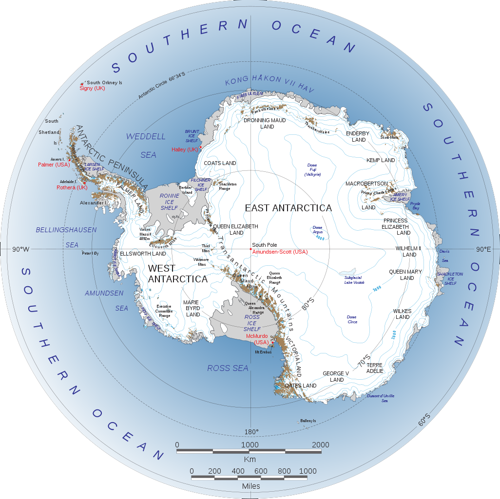
Antarctica (/ænˈtɑːrktɪkə/) is Earth's southernmost and least populated continent. Situated almost entirely south of the Antarctic Circle and surrounded by the Antarctic Ocean (also known as the Southern Ocean), and contains the geographic South Pole. It is the fifth-largest continent, being about 40% larger than Europe, and has an area of 14,200,000 km2 (5,500,000 sq mi). Most of Antarctica is covered by the Antarctic ice sheet, with an average thickness of 1.9 km (1.2 mi).
Antarctica is on average, the coldest, driest, and windiest of all continents, and has the highest average elevation. It's mainly a polar desert, with annual precipitation of 200 mm (8 in) along the coast, with far less inland. It holds the record for the lowest ever measured temperature on Earth, −89.2°C (−128.6°F). The coastal regions can reach temperatures over 10°C (50°F) in the summer. Antarctica is colder than the Arctic region, as much of Antarctica is over 3,000 m (9,800 ft) above sea level, where air temperatures are colder. Native species of animals include mites, nematodes, penguins, seals and tardigrades. Where vegetation occurs, it is mostly in the form of lichen or moss.
Antarctica is governed by about 30 countries, all of which are parties of the 1959 Antarctic Treaty System. During the summer months, about 5,000 people reside at research stations, a figure that drops to around 1,000 in the winter. Thousands of expeditions have taken place across the continent, for adventure as well as science. However, due to the challenging terrain and extreme temperatures, many areas of Antarctica have not yet been fully explored, including most of East Antarctica.
At all locations in Antarctica, the sun rises and sets based on seasons rather than days as it does in mid-latitudes; hence the famous polar six months of daylight and six months of darkness.
Do note that sometimes when temperatures become too low (i.e. too cold), the webcams might have problems producing usable images. Plus, you will find that many of the cams in Antarctica don't update as often as most live webcams elsewhere do, in part because of the extreme cold environment.
(Note: This page may need reloading on some browsers for new views)
We currenty show 13 webcams from Antarctica:
Observation Hill, McMurdo U.S. Station, Antarctica
(Cams from U.S.
Artic Program)
McMurdo Station, the main U.S.
station in Antarctica, is a coastal station at the southern tip of Ross Island,
about 2,415 miles (3,864 km) south of Christchurch, New Zealand, and 850 miles(1,360
km) north of the South Pole. The original station was built in 1955 and 1956 for
the International Geophysical Year. Today's station is the primary logistics
facility for supply of inland stations and remote field camps, and is also the
waste management center for much of the U.S. Antarctic Program. Year-round and
summer science projects are supported at McMurdo. The station is the largest community in Antarctica,
with 1,200 summer residents living
here while 250 individuals brave the winter harshness. It boasts over a hundred
(approximately 146) permanent structures, including
its scientific laboratories, administrative buildings, workshops, dormitories, and recreational facilities.
It also has a golf course, a fire station, post office, and two bars. It also
has WIFI, but at only 17 mbps connection speed, and it's a shared connection at that.
So it's real slow, and gaming
is unlikely (but still possible). Plus Starlink service is now being tested here, so speed may improve in time. The Arrival Heights Webcam is located on the edge of Arrival Heights just north of Hut Point on the west side of Hut Point Peninsula. The image shows fuel storage containers in the foreground, and housing, maintenance, and administrative facilities in the center. Observation Hill (Ob Hill) appears in the background.
The Ob Hill Webcam is located at the base of Ob Hill, a very large feature adjacent to McMurdo Station, approximately 750 feet (230 meters) high. The Ob Hill webcam is focused on McMurdo Station with a view showing the Crary Science and Engineering Center, McMurdo Sound and the pier on the left, and several dormitories to the right.
The mean annual temperature
at
McMurdo Station
is
-0.4⁰F (-18⁰C). Highest temperature reach is 46.4⁰F
(8⁰C) in summer and -58⁰F (-50⁰C) in winter. The average wind is 14 mph (12
knots), but winds have exceeded 115 mph (100 knots). Annual Snowfall: Accumulation can reach up to 1.5 meters (59.1
inches or
4.9 feet) annually. But the station is typically snow-free in summer.
(from NOAA
-
Next, U.S. Amundsen-Scott South Pole Station -
Amundsen-Scott South Pole Station
This South Pole station is one of three year-around stations operated by the U.S. National Science Foundation (NSF). Amundsen-Scott South Pole Station sits at the Earth's axis on a shifting continental ice sheet several miles thick. The station is a unique research site that supports projects ranging from cosmic observations to seismic and atmospheric studies. The extremely dry, cold air is perfectly suited for observing Cosmic Microwave Background (CMB) radiation-the faint light signature left by the Big Bang that brought the universe into being nearly 14 billion years ago. Another large astrophysical project at the pole is IceCube—a one-cubic-kilometer international high-energy neutrino detector built in the clear ice, 1.25-2.5 kilometers below the South Pole Station.
At an elevation of 2,835 meters (9,300 feet), the South Pole is the coldest place on Earth, and is consistently colder than the North Pole. It has an average monthly temperature in the summer of -28°C (-18°F); in the winter, the average monthly temperature is -60°C (-76°F). Extreme temperatures: The average annual temperature is about -49.3°C (-56°F). The record coldest low was -82.8°C (-117.0°F), while the record high was only -12.3°C (9.9°F).
Antarctica as a whole is the driest continent on Earth, and its interior, where the South Pole is located, receives the least amount of moisture, making the South Pole a extreme polar deser, with very low humidity and minimal precipitation. Much of the minimal precipitation that occurs is not large, fluffy snowflakes, but instead fine ice crystals known as "diamond dust", typically accumulating only about 7–9 inches (approximately 18–23 cm) of snow per year.
It is important to distinguish between snowfall and snow accumulation at the South Pole: Snowfall is the precipitation from the sky. Again, because of the extremely low moisture in the air, there is very little of it. Snow accumulation is the net result of new snow plus the snow that is deposited by the wind. Over time, this accumulation is what causes buildings and other structures to become buried. Studies have also observed that long-term accumulation rates have increased in recent decades. Also note than because of these factors, no official "snowiest year" record exists for the South Pole.
Seasonal light cycle: The sun rises around September 21 and sets around March 21, leaving the South Pole in continuous daylight during the austral summer and six months of darkness during the winter.
Scott Base, a New Zealand Antarctic research station, is located on a low volcanic headland called Pram Point, at the southern end of Ross Island. It is 1350km/839 miles from the South Pole. Mt Erebus, an active volcano, sits north-east and to the west. From October to February, Scott Base is a very active hub of scientists, staff and visitors. Up to 86 people can be accommodated at any one time; during the summer season, and more than 300 people stay on base.
Commissioned in 2005, the Summer Technical Support staff and servers are also located in this facility, at Hillary Field Center (HFC). There are three lab spaces in the HFC. The Margaret Bradshaw lab is the largest space and is set up to allow event personnel to prepare, run and break down experiments, equipment and technology. The Thelma Rodgers Lab is an internal wet lab which has autoclave, oven, fume cabinet, refrigerator and freezer for samples. There is also a walk-in -20°C science freezer nearby. The Pamela Young Lab is the electronics lab that is equipped with bench space and antistatic precautions for higher end technological work such as with remote operating vehicles and drones.
Scott Base weather facts:Wind:
Mean speed 11.9 mph (19.1 km/h), Max speed 110.5 mph (177.8km/h), Dominant
wind direction: NE; Temperature:
Mean annual temp: -3.6⁰F (-19.8⁰C), mean temp in February: 11.7⁰F (-11.3⁰C),
Mean temp in July: -20.2⁰F (-29.0⁰C), Lowest recorded temperature at Scott
Base: -70.6⁰F (-57.0⁰C (25 September 1968). To see real time weather updates from
Scott Base, click here.
Ross Island Wind Farm,
Antarctica
(From Antarctica
NZ)
Located on Ross Island's Crater Hill, the wind farm has three wind turbines that supply renewable energy for New Zealand's Scott Base and the American base at McMurdo Station. The wind farm has had a big impact since it was built in 2008-9 and started up in '09. The base’s annual fuel consumption has been cut by approximately 463,000 liters/122,312 gallons, and greenhouse gas production from both bases has been reduced by 1,242 metric tons/27,381 pounds of carbon dioxide. The Crater Hill site was selected because it has a high average annual wind speed of 28.4 kilometers/18 miles per hour, at a height of 39 meters/128 feet (the height of the wind turbine’s hub). It’s also one of the few ice-free areas on Ross Island.
Rothera, Antarctica
(From
British Antarctic Survey)
Rothera Research Station, the largest British Antarctic facility, is a center for biological research and a hub for supporting deep-field and air operations. Situated on Adelaide Island, just to the west of the Antarctic Peninsula (see the second map below) the site includes the Bonner research laboratory. Rothera station was established in 1975 to replace Adelaide station (1961–1977) after the skiway (airstrip) had deteriorated at Adelaide. The station is open throughout the year with a maximum population of 160 in the summer and an average winter population of 27.
Rothera is located just South of the Antarctic Circle. Climate wise, the mean yearly temperature here is −5.3⁰C (22.4⁰F), mild for Antarctica.
Halley British Research Station is an internationally
important platform for global earth, atmospheric and space weather
observation in a climate sensitive zone. Built on a floating ice shelf in
the Weddell Sea, Halley VI is the world’s first re-locatable research
facility, and while the station is designed for year-round habitation, it is now only occupied during the much safer summer months due to concerns about the stability of the floating Brunt Ice Shelf.
This research station provides scientists with state-of-the-art laboratories and living accommodation, enabling them to study pressing global problems from climate change and sea-level rise to space weather and the ozone hole.
In 2013, Halley was made part of the network of 30 stations across the globe that form the World Meteorological Organization’s Global Atmosphere Watch (GAW)
program, becoming the 29th in the world and 3rd in Antarctica. Together, these stations provide reliable information on the chemical composition of the atmosphere and how it is changing.
Measurements of ozone, as well as meteorology, have been made at Halley since it was established in 1956. This long-term data enabled British scientists to discover the hole in the ozone layer in 1985.
At Halley there is 24-hour darkness for 105 days per year.
Temperatures at Halley rarely rise above 0°C (32°F) although temperatures around -10°C
(50°F) are common on sunny summer days. Typical winter temperatures are below -20°C
(-4°F) with extreme lows of around -56°C (-68.8°F), with strong winds exceeding 160 kph (100 mph). Snow accumulates at about 1 meter
(39.4 inches or 3.3 feet) per year.
Troll research station, Antarctica
(From Norwegian Polar Institute)
Troll is a Norwegian research station located at Jutulsessen, 235 kilometers (146 miles) from the coast in the eastern part of Princess Martha Coast in Queen Maud Land, Antarctica. Norway's only all-year research station in Antarctica, it is supplemented by a summer-only station Tor. Unlike most other research stations on the continent, Troll is constructed on the snow-free slope of solid rock breaking through the ice sheet at Jutulsessen, at an elevation of 1,275 meters (4,183 feet) and is located 235 kilometers (146 mi) from the coast. It has an winter population of just six people and in summer there's 70.
Being located in a desert, the station has a cold, dry climate. The annual mean temperature is −25°C (−13°F), with the summer temperature reaching to about 0°C (32°F) with the lowest temps during the winter at −50°C (−58°F). Storms, can occur throughout the year and can occasionally make outdoor activity impossible. Located south of the Antarctic Circle, Troll has nighttime sun in the summer (from about November 9th to February 1st) and a polar night during the winter (from about May 15th to July 27th).
Palmer Station (US) near Esperanza Station (Argentina), Antarctica
Esperanza Station (Spanish: Base Esperanza, 'Hope Base') is a permanent, all-year-round Argentine research station in Hope Bay, Trinity Peninsula (in Graham Land on the Antarctic Peninsula). It is the only civilian settlement on the Antarctic mainland and one of only two civilian communities in Antarctica, distinct from the military and scientific bases on the continent (the other is Villa Las Estrellas [Chile]). Built in 1953, the base houses 56 inhabitants in winter, including 10 families and 2 school teachers. Besides having a school, it also has a hospital, a post office, and a community center. The base has an Argentine civil register office where births and weddings are recorded. The base has tourist facilities that are visited by about 1,100 tourists each year.
Eleven babies have been born in Antarctica, all of them at Esperanza Base, between 1978 and 1983. The first child born on the continent was Emilio Marcos Palma in 1978. These births were part of strategic efforts by the Argentine and Chilean governments to legitimize their territorial claims on the continent. Today, most Antarctic programs, including those of the US, UK, Australia, New Zealand, and South Africa, have a policy against sending pregnant women to the continent and will send them home if pregnancy occurs.
The 43 buildings at the station have a combined space of 3,744 square meters (40,300 sq. ft.) covered; 18,000 liters (4,800 US gal) of fuel are used annually by the four generators to produce electricity for the station. Research projects include: glaciology, seismology, oceanography, coastal ecology, biology, geology, and limnology.
Like the rest of the Antarctic Peninsula, the climate here is classified as a polar tundra climate, characterized by strong winds that descend downwards from the Antarctic ice sheet. These winds can exceed 250 km/h (160 mph), leading to blowing snow and reduced visibility. Mean monthly temperatures range from -10.8°C (12.6 °F) in July, the coldest month, to 1.5 °C (34.7 °F) in January, the warmest month. During summer (December–February), the average high is between 3.8 and 4.3°C (38.8 and 39.7°F) while the average low is between −2.0 and −1.2°C (28.4 and 29.8°F). In winter, mean temperatures are around −10.2°C (13.6°F). The highest temperature ever recorded on mainland Antarctica and its surrounding islands happened on 6 February 2020, when a reading of 18.3°C (64.9°F) was recorded at the base, being the current record and considered by the World Meteorological Organization to be the highest temperature ever recorded for mainland Antarctica and its surrounding islands. The lowest temperature ever recorded is −38.4°C (−37.1°F) on 18 July 1994. Average precipitation here is 726.4 mm (28.6 inches). Average snowy days is 178.6 a year, and almost all precip falls as snow. However, while rain is very rare here, yes, it can rain at Esperanza Base. When this rare event does occur, the rain is usually mixed with snow, forming a "rain-snow mix" However, most precipitation at Esperanza Base, and in Antarctica generally, falls as snow or ice crystals.
The old webcam that was once at this base is no more, so we show one that is closest to it today, at Palmer Station (U.S.), located on Anvers Island near the Antarctic Peninsula. Both stations are located in the same general region of the Antarctic Peninsula, yet they are located at opposite ends of the peninsula, with Palmer Station on the western side and Esperanza Base on the eastern side. The straight-line distance "as the crow flies" between Palmer Station and Esperanza Station is approximately 362 miles (584 kilometers). Travel between the two involve a sea journey across the peninsula's difficult terrain, as no direct land or air route exists, with the most practical approach being to take a ship or boat.
(From AWI)
- Maps -
This map from
https://gisgeography.com/
Next, Map showing the many research stations' locations:
Worldwide Webcams Home Page | Colorado Web Cams | New York Webcams | New York City Webcams | Long Island Webcams |